
Spangereidkanal

The Spangereid Canal runs right through the Lindesnes peninsula in the Norwegian municipality of Lindesnes. It leads through Spangereid from Store Båly to Lehnesfjord . The southern entrance is at the port of Båly, which is a popular destination with its boat moorings.
The canal, which was built between 2006 and 2007, is 930 m long, between 11 and 25 m wide, has a navigable depth of 2 m and a passage height of 4.50 m.
After more than twenty years of planning, the municipality decided to build it in 2005 and received funding commitments from the state, neighboring municipalities and regional private companies. The intention of the canal was to offer recreational boat traffic the possibility of not having to bypass Cape Lindesnes on the open sea. Since the headroom is only 4.50 m, most sailboats still have to choose the route across the open sea.
history
The history of the canal goes back to the 8th century and is unique in Norway. Viking ships have presumably already passed through the canal, but over time the canal filled up and has recently disappeared completely.
Many isthmuses offered such a possibility, but ships were usually pulled over a wooden path called spong (in the plural spenger ) in Norwegian .

Iron age
Excavations carried out in 2001 show that a canal through the isthmus existed as early as 700. A canal 12 m wide and 2 m deep was found, as well as impressions of piles driven deep into the ground and remains of a wooden paneling of the canal walls. This find is unique in Norway and shows one of the largest Iron Age buildings in Norway.
16th to 19th century
A rough description is known from a map made in 1724 , but also from a legal dispute that began in 1595 and was not concluded until 1787, almost 200 years later. One party claimed the canal as the property line. There is no mention of boats there.
Plans for a canal across the isthmus at Høllen are old. Around 1600 Peder Claussøn Friis wrote about this channel in the book Norriges oc Omligende Øers sandfærdige Bescriffuelse (printed 1632). He describes how attempts were made in the past to dig a sewer but had to be abandoned when they encountered rock.
Plans for a canal have been revived since then, most recently in the 1880s. In 1810, during the war against Great Britain , a Lieutenant Captain Michael Bille was sitting on Spangereid and wrote a letter to the King in Copenhagen , in which he asked for a canal to be built across the isthmus that would make voyages against the English conquerors safer.
places
Dronningbrygga
The Dronningbrygge (German: the Königinnenkai ) is a 60 m long quay named after Queen Sonja , who officially opened the canal on July 5, 2007 . The quay is at the southern end of the canal at the mouth of the Lehnesfjord.
present
Around 1990 the mayor of Lindesnes municipality, Ansgar Gabrielsen , added the canal to the municipal area plan.
On June 22, 2007, the canal was opened to traffic with a wreath-laying ceremony by Mayor Ivar Lindal , a strong advocate for the construction of the canal. The official opening will be made by Queen Sonja on July 5, 2007 with guests from royal families from all over Europe.
financing

The estimated cost is around 40 million Norwegian crowns , including the adaptation of roads, pedestrian and cycle paths and bridges.
Contribute financially:
- the Norwegian State through the Ministry of Transport 7 million for the relocation of Reichsstrasse 460;
- the province of Vest-Agder 9 million, of which 7.5 million for the repair and relocation of the provincial road and up to 1.5 million for the local development of Høllen in the area of the canal;
- the municipality of Lindesnes 4 million through the acquisition of land;
- the Mandal commune 1 million;
- Lyngdal Municipality 0.8 million.
Private companies have also donated small and large amounts.
Picture gallery

The southern of the two bridges over the canal
Photo: Philip Gabrielsen
The northern of the two bridges over the canal
Photo: Philip Gabrielsen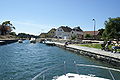
The Königinnenkai, named after Queen Sonja
Photo: Philip Gabrielsen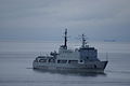
KNM “Horten” visiting during the opening
Photo: Philip Gabrielsen


Web links
Individual evidence
- ^ Einar Nord, Gunnar C. Wasberg: Magiske Mølen . Larvik og Omegns Turistforening.
Coordinates: 58 ° 2 ′ 45 ″ N , 7 ° 8 ′ 28 ″ E