Site of the Stone City
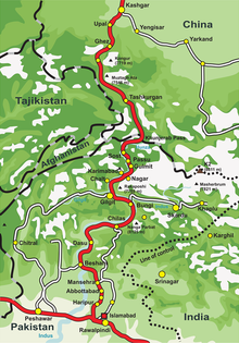
The site of the Stone City or Tashkorgan (" Stone City ", Chinese 石头城 遗址 , Pinyin Shítou chéng yízhǐ , English Ruins of Stone City / Tashkurgan stone city ) is located in the north of the Tajik Autonomous County of Tashkorgan ( 塔什库尔干 塔吉克 自治县 ), Xinjiang , China , 200 kilometers south of the city of Kashgar on the old Silk Road . It is about 3,300 m above sea level in the four-country corner of China, Pakistan, Afghanistan and Tajikistan, Kyrgyzstan and Kazakhstan are not far away. Taxkorgan (Tashkurgan) means “stone city” in Tajik , which alludes to its strong stone wall, the circumference of which is over 1,300 meters.
history
The history of the city can be traced back 2000 years to the time of the Han Dynasty . It was the capital of the Puli Kingdom ( Puli guo蒲 犁 国), one of the thirty-six empires of the Western Regions ( Xiyu Sanshiliu guo西域 三 十六 国) (cf. Xiyu ) of the Han Dynasty. During the time of the Wei and Jin dynasties , it gradually expanded.
After the unification of the Western Regions during the Tang Dynasty , the Pamir Military Office ( cōnglǐng shǒuzhuō葱岭 守 捉) was established here. At the beginning of the Mongol dynasty , the city was rebuilt. The Puli Department ( Puli ting蒲 犁 厅) and Puli County ( Puli xian蒲 犁 县) were established here in the Qing Dynasty , and the city was restored in the Guangxu era to the extent that they are seen today can. Its city gates, city walls, loopholes and battlements are well preserved.
The site was added to the List of Monuments of the People's Republic of China in Xinjiang (5-138) in 2001.
gallery
Web links
Footnotes
- ↑ It must not be confused with the site of the same name in Nanjing (Jiangsu Province) or the one in Liaoyang (Liaoning Province)
Coordinates: 37 ° 46 ′ 16 ″ N , 75 ° 13 ′ 43 ″ E


