Stürzlieder mountain
| Stürzlieder mountain | ||
|---|---|---|
|
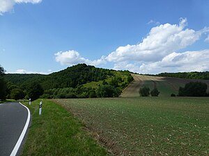
The Stürzlieder Berg seen from the direction of Bornhagen |
||
| height | 342.9 m | |
| location | Eichsfeld district , Werra-Meißner district | |
| Mountains | Neuseesen-Werleshäuser heights , Lower Werrabergland | |
| Coordinates | 51 ° 21 '11 " N , 9 ° 55' 32" E | |
|
|
||
| rock | Shell limestone and other rocks | |
The Stürzlieder Berg is a 342.9 m high mountain in the border area of the districts of Eichsfeld (TH) and Werra-Meißner (HE) ( Germany ).
The mountain is located between the villages of Neuseesen in the southwest, Hohengandern in the north and Bornhagen in the southeast. The nearest town Witzenhausen is about four kilometers to the west and Heilbad Heiligenstadt is about 14 km to the east. The former inner German border and today's Green Belt Germany ran over the mountain .
The Stürzlieder Berg is forested in the south and west, to the north and east it is also used for agriculture. There are also smaller lime-grass complexes with rare plants and animals. To the southwest, the hilltop borders on the Stürzliede (354.2 m) and to the northeast on the Altes Holz forest area (335 m), which is already included in the neighboring Upper Leinegraben .
In 1983 there was a helicopter crash of the Soviet armed forces in the area of the Stürzlieder Mountain in the immediate vicinity of the then border .

