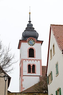
St. Martin (Herrnsheim Market)
The simultaneous church of St. Martin is the house of worship of the Evangelical Lutheran and the Catholic community in Markt Herrnsheim in Lower Franconia . It stands in the middle of the fortified church Markt Herrnsheim in the center of the village. It belongs to the Evangelical Lutheran Deanery Markt Einersheim and the Deanery Neustadt an der Aisch in the Archdiocese of Bamberg .
history
The history of the church is closely linked to that of the village. The Counts of Schwarzenberg were wealthy in the village, along with others, and promoted their possessions. Johann der Starke von Schwarzenberg introduced the Reformation in 1524 with the appointment of pastor Gallus Korn in the village . Herrnsheim had its own parish since the 14th century; it was first mentioned in documents in 1328. The village remained Lutheran for several decades until the Protestant line of the Schwarzenbergs died out.
After 1588, the Bavarian Schwarzenbergs took over the rule of the village and carried out the Counter-Reformation until 1627 . However, Johann von Schwarzenberg had transferred the patronage right , i.e. the right of appointment of the respective pastor, to the Protestant Margraves of Ansbach , so that Lutheran pastors were also appointed in the predominantly Catholic Herrnsheim. After this tradition came to an end, the people of Herrnsheim began to attend Lutheran services in Mönchsondheim .
In 1664, a compromise was reached in the Kitzinger Recess . The Lords of Schwarzenberg set up a Simultaneum in the Herrnsheim Church so that both denominations could hold services there. The simultaneous church is still in use today, so the Catholics are allowed to hold their services there annually on market days and at the parish fair. The Lords of Schwarzenberg held the right of patronage over the pastor in Herrnsheim until the 1960s. The church is listed as an architectural monument .
architecture
The church rises in the middle of the closely standing, almost completely preserved fortified church. The church was built around 1200, as indicated by the Romanesque church tower. It is structured by a round arch frieze on the third floor and stone columns. In 1781 the tower was raised and in 1821 it was given the neo-baroque helmet. The second oldest part is the early Gothic choir , which dates back to around 1300. It ends inside with a ribbed vault, which is decorated with figurative consoles. On the outside, the tower was fitted into the fortification of the fortified church. The nave was changed in the 18th century.
Furnishing
Inside the church, works of art from most eras since the Middle Ages have been preserved. Three bells in the tower date from the 14th, 15th and 16th centuries. Unlike most of the other bells , they were not used for melting down during the world wars, so that the oldest bell in the area was preserved there. The sacrament house in the choir room dates from around 1400 . It shows the face of the suffering Christ and ends with Gothic pegs .
The baptismal font is much younger, from the time of the Counter-Reformation . It was created in 1607 and 1609 in the form of a chalice. The most recent element of the furnishings is the altar in the choir room. It was created by an unknown artist in 1957 and shows the Ascension of Christ with three plastic figures made of wood.
literature
- Hans Bauer: District of Kitzingen. An art and culture guide . Market wide 1993.
- Theobald Kinkelin, Richard Schmitt: Herrnsheim . In: Harmut Preß (Ed.): Deanery Markt Einersheim. Evangelical parishes in the Steigerwald . Erlangen 1978. pp. 37-39.
Web links
Individual evidence
- ↑ Kinkelin, Theobald (among others): Herrnsheim . P. 37.
- ↑ Kinkelin, Theobald (among others): Herrnsheim . P. 38.
- ^ Castell culture path: Markt Herrnsheim , accessed on March 19, 2019.
- ^ Bauer, Hans: District of Kitzingen . P. 120.
Coordinates: 49 ° 39 ′ 35.6 " N , 10 ° 14 ′ 33.3" E
