City Bridge Frankfurt (Oder)
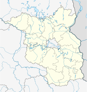
Coordinates: 52 ° 20 ′ 52 ″ N , 14 ° 33 ′ 21 ″ E
| City Bridge Frankfurt (Oder) | ||
|---|---|---|
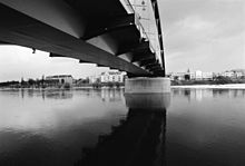
| View from the southeast | ||
| Convicted | Bundesstrasse 5 , Nationalstrasse 29 and Nationalstrasse 31 | |
| Subjugated | Or , km 584 | |
| place | Frankfurt (Oder) , Słubice | |
| construction | Tied arch bridge | |
| overall length | 251.75 m | |
| width | 15.2 m | |
| Longest span | 75 m | |
| Construction height | 2.32 m | |
| location | ||
|
|
||
| Above sea level | 25 m | |
The city bridge Frankfurt (Oder) is a bridge structure of the federal highway 5 , which spans the Oder in Frankfurt (Oder) . The border bridge is located in the course of the inner-city border crossing between Frankfurt and Słubice . It spans an Oder promenade, the Oder waterway, a port entrance and a flood plain. The state border between the two countries runs in the middle of the Oder navigation channel, so that around 70% of the bridge is on Polish territory.
On the Polish side it is called Grenzbrücke (Polish Most Graniczny ).
history
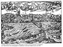
After Johann I. Margrave of Brandenburg granted Frankfurt city rights in 1253, the first bridge over the Oder was built. Due to its location on the Paris – Berlin – Warsaw – Moscow trade route, the city possessed the only Oder crossing of supraregional importance besides Breslau . However, in the following centuries ice, floods or wars repeatedly destroyed the wooden bridge at this location, for example a severe ice drift in March 1805. After the lost Russian campaign , the wooden bridge was burned down in February 1813 by fleeing French troops. The new building was completed in 1819 and meanwhile also served in the inner city to connect the city center and Dammvorstadt.
On April 1, 1892, construction work began on a massive arched bridge below the last wooden bridge, in line with Breite Straße. On December 10, 1895, the new structure over the Oder was inaugurated. The old wooden bridge was demolished in 1896. From the end of 1898 a tram line also crossed the bridge to Dammvorstadt. On April 19, 1945, German troops blew up the vault bridge. A makeshift bridge as a wooden structure was built in May 1945 north of the destroyed bridge.
From 1951 the bridge structure from 1895, now as a border bridge between Germany and Poland, was rebuilt. The new building was erected as a girder bridge on the old foundations or pillars. The demolition of the western pillar of the river and the installation of a steel arch bridge doubled the clear width of the shipping channel. In 1952 the bridge was completed and was named the Bridge of Friendship . Until 1972, the border bridge was only passable with special permission or an official invitation. On January 1, 1972, the agreement on passport-free and visa-free cross-border traffic between the GDR and Poland came into force. Until the termination of the agreement on October 30, 1980, an average of 8,000 people used the bridge every day. After April 8, 1991 with the introduction of visa-free border traffic, the border bridge was used by around eight million people annually; in 1995 there were 4,360 vehicles a day.
The poor state of construction of the city bridge made a completely new building necessary at the beginning of the 21st century with construction costs of 10.5 million euros, which began at the end of 2000 and was completed at the end of 2002. Since then, the bridge has spanned the Oder with a 9.0 m wide carriageway for three lanes and 2.8 m wide sidewalks with five openings on both sides. The traffic load is around 5000 vehicles a day.
construction
Bridge from 1895
The first massive bridge was a 264 m long and 14.5 m wide arch bridge , which spanned the Oder with eight brick vaults and pillar spacings of up to 34 m. After the spring flood of 1893 had undermined a finished pillar foundation, the pillars were founded on caissons .
Bridge from 1952
The 253 m long bridge had only seven openings and was built on the old, but elevated pillars. On the western bank it consisted of a girder bridge with a span of 28.6 m, followed by a tied arch bridge with a span of 65.0 m and five further fields with haunched beam cross-sections and spans of 34.05 m, 34.05 m, 33.2 m, 31.4 m and 26.7 m. The girder bridges had a five-web T- beam cross-section made of reinforced concrete . The steel tied arch bridge had two truss side girders and an orthotropic deck .
Bridge from 2002
The bridge consists of two-sided approach bridges and the main bridge. The span of the girder bridge for the jointless five-span construction is 27.8 m, 75.0 m, 50.0 m, 50.0 m and 48.95 m, which results in a total span of 251.75 m. The constant 2.32 m high carriageway girder is a composite steel box girder, with a 6.5 m wide lower flange designed as an open U-section made of steel.
The main opening is bridged by a beam reinforced by two arches. The parabolic arches are arranged vertically at a center distance of 16.1 m and have a maximum height of 12.0 m above the roadway. The box girder is carried by six hangers, each made of round steel profiles, at a distance of 8.6 m. The 1.1 m wide arches have airtight welded rectangular box cross-sections with heights of 0.85 m at the top of the arch and 1.7 m at the base of the arch.
The new bridge was built next to the old bridge and, after the old structure was demolished, moved across its axis. The border crossing was closed to motor vehicles for two weeks and pedestrians for two days.
Structural changes
The border clearance buildings on the German side have now been completely removed. In 2014, a district heating pipe was built into the bridge box in order to exchange 16,000 megawatt hours of district heating between the municipalities each year.
literature
- Federal Ministry of Transport, Building and Urban Development: Bridges and tunnels on federal highways 2003 . ISBN 3935064209 , pp. 7-24.
- Olaf Krumbein: New construction of the city bridge Frankfurt / Oder – Slubice . In: Tiefbau , 2005, Issue 9, pp. 514–516. (PDF file)
- Josef Einhaus, Heinz Schmackpfeffer, Gregor Gebert: The border bridge on the B 5 over the Oder between Frankfurt (Oder) and Slubice . Proceedings 13th Dresden Bridge Construction Symposium, 2003, pp. 157–174.
Web links
Individual evidence
- ^ National register of geographical names, Central Office for Geodesy and Cartography in Warsaw
- ↑ Homepage slubice.de & frankfurt.pl: “Bridge of Friendship” would be 50 years old
- ↑ Andrea Witt: The German-Polish and the US-Mexican border - cross-border cooperation between regional identity, national priority and transcontinental integration. Dissertation, Humboldt University Berlin, 2003. pp.99, 105 (PDF; 1.7 MB)
- ^ State of Brandenburg, Ministry for Urban Development, Housing and Transport: Border Crossings Federal Republic of Germany - Republic of Poland . Brochure, October 2003, p. 16 ( Memento from April 26, 2005 in the Internet Archive )
- ↑ Oscar-Henri Pekoll: City Bridge Frankfurt / Oder. Conference volume 3rd Colloquium Building in Soil and Rock, Technical Academy Esslingen, 2002, pp. 246-258. ( Memento from November 23, 2010 in the Internet Archive )


