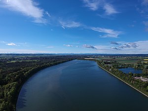
Dettingen reservoir
| Dettingen reservoir | |||||||||
|---|---|---|---|---|---|---|---|---|---|
| Dettingen reservoir (2019) Aerial view towards the south | |||||||||
|
|||||||||
|
|
|||||||||
| Coordinates | 48 ° 6 '18 " N , 10 ° 8' 13" E | ||||||||
| Data on the structure | |||||||||
| Construction time: | 1926-1928 | ||||||||
| Height above foundation level : | 16 m | ||||||||
| Crown length: | 3 600 m | ||||||||
| Data on the reservoir | |||||||||
| Water surface | 52 ha | ||||||||
| Storage space | 2.1 million m³ | ||||||||
The Dettingen reservoir is located in Dettingen an der Iller in the Biberach district and around twelve kilometers north of Memmingen in Baden-Württemberg near the border with Bavaria .
It is located on the Illerkanal next to the Iller , a tributary of the Danube. The reservoir , the canal power station and the Illerkanal were built between 1926 and 1928 by the Oberschwäbische Elektrizitätswerke to generate energy. Today EnBW is the operator of the hydropower plant . The barrier structure is a 16 m high gravity dam .
The fishing on the lake was in the hands of KSFV Biberach e. V.
See also
Web links
- EnBW - there page 3 (PDF file; 1.14 MB)
- Our Spitz (en) Weiher - fishing information

