Steinbach (Sassnitz)
| Steinbach | ||
|
The Steinbach flows into the Baltic Sea |
||
| Data | ||
| Water code | DE : 966312 | |
| location | Mecklenburg-Western Pomerania | |
| source | in the Jasmund National Park 54 ° 32 ′ 25 ″ N , 13 ° 39 ′ 10 ″ E |
|
| Source height | 123 m above sea level NHN | |
| muzzle | in the Baltic Sea coordinates: 54 ° 31 ′ 0 ″ N , 13 ° 39 ′ 24 ″ E 54 ° 31 ′ 0 ″ N , 13 ° 39 ′ 24 ″ E |
|
| Mouth height | 0 m above sea level NHN | |
| Height difference | 123 m | |
| Bottom slope | 33 ‰ | |
| length | 3.7 km | |
| Small towns | Sassnitz | |
The Steinbach is a brook in the city of Sassnitz on the island of Rügen .
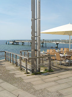
The stream rises in the Jasmund National Park and then flows south out of the National Park and through the built-up area of the city of Sassnitz. Outside the national park, it has been completely piped since 1860, but a small section of the route was reopened in 2003: it is piped from the pond in the Sassnitz zoo, then the reopened section that extends to Bergstrasse follows. Below Bergstrasse it flows piped between Rosenstrasse and Marktstrasse and then along the “Bachpromenade” street through the old town down to the beach promenade. There it flows into the Baltic Sea near the pier . Since the redesign of the beach promenade in 1995, the mouth has been exposed again and is marked by a metal pillar.
In Sassnitz, in addition to the “Bachpromenade” street, the “Bachstraße” and the “Steinbachweg” are named after the brook. In addition to the Steinbach, the Tribberbach in Sassnitz-Lancken also flows through the built-up area of the city.


