Steinberg (Seifersdorf)
| Steinberg | ||
|---|---|---|
|
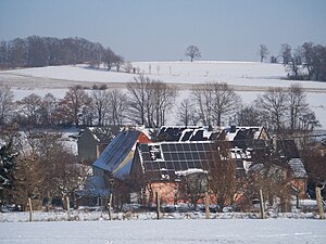
Steinberg seen from the Follow Mountain |
||
| height | 264 m | |
| location | Saxony , Germany | |
| Coordinates | 51 ° 9 '46 " N , 13 ° 53' 8" E | |
|
|
||
|
Seifersdorf and the Steinberg on a map from 1841/43 |
||
The Steinberg is a mountain in the Radeberger Land in Saxony . It is 264 meters high and is located approx. 0.5 km north of the Seifersdorf village, directly on the old Bohemian Glass Road (also known as the Salt Road ). Especially to the west and north there is an excellent view. In the north, the Keulenberg dominates the panorama.
Morphologically , the Steinberg lies on a 100 meter thick quartz dike that penetrates the granite massif . This quartz vein can be traced in a west-northwest direction over 5 km. The Diensdorfer Berg (232 meters) upstream in this direction belongs to it morphologically.
Old writings call the mountain Kappelgenberg . A chapel is said to have stood here in pre-Reformation times . Today the six-meter-high, wooden Luther cross , which was erected in 1883 for the Luther anniversary, is located in a small forest . Not far from the grove on Alte Straße is a stone cross in front of a linden tree. This cross is documented as a murder cross . In 1678 Georg Hille, a servant of the Grünrods ruling knight dynasty in Seifersdorf at that time, was stabbed to death by Wolf von Thümmel. Another stone cross is located on Ottendorfer Straße not far from the Diensdorfer Berg.
Individual evidence
- ↑ Hiking map, sheet 36 Dresdner Heide / Laußnitzer Heide of the State Surveying Office Saxony 2004
- ↑ Walther Buchholz, Guide through the Seifersdorfer Tal, 1930, page 30


