Flagstone cave
| Flagstone cave
|
||
|---|---|---|
| Location: | Kugelstein near Frohnleiten , Styria / A | |
| Height : | 422 m above sea level A. | |
|
Geographic location: |
47 ° 13 '36.1 " N , 15 ° 19' 59.4" E | |
|
|
||
| Cadastral number: | 2784/13 | |
| Geology: | Schöcklkalk | |
| Lighting: | No | |
| Overall length: | 16 m | |
| Level difference: | 3 m | |
| Particularities: | some stalactites | |
The stone slab cave near Frohnleiten is 422 m above sea level. A. im Kugelstein north of the main town of Deutschfeistritz and southwest of Badl , Styria in Austria .
location
The stone slab cave is located on the northern slope of the globular stone, southwest of the layer joint cave . It is the westernmost of the Kugelstein caves on the north slope. The access to the cave is at the foot of a rock wall, which rises over a road running in a south-west-north-east direction. The entrance to the cave is about 3 to 4 meters above this road.
description
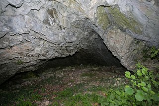
The 16-meter-long stone slab cave has an entrance about 7 meters wide and 3 meters high. The entrance leads to the approximately 5 meter long vestibule, which ends in a narrow passage. This bottleneck was enlarged during research work in 1963. Behind the narrow point, there is another 2 to 3 meters wide and 1 to 1.7 meters high room with some stalactites , which extends 7 meters into the mountain. No other rooms branch off from this room.
The cave floor is covered with earth and rubble in the anteroom and with stone slabs and frost rubble in the room behind the narrow point.
swell
- Heinrich Kusch : The caves in Kugelstein near Peggau (Styria) . In: The cave . tape 023 , 1972, p. 145–157 ( PDF (4.3 MB) on ZOBODAT ).

