
Stråken
| Stråken | ||
|---|---|---|

|
||
| Geographical location | Sweden | |
| Drain | Tidan | |
| Places on the shore | Mullsjö , Bottnaryd | |
| Data | ||
| Coordinates | 57 ° 52 ' N , 13 ° 52' E | |
|
||
| Altitude above sea level | 207.6 m above sea level | |
| length | 22 km | |
| width | 580 m | |
| Maximum depth | 38 m | |
| Middle deep | 10 m | |
| Catchment area | 406.7 km² | |

The Stråken is a lake in the Swedish province of Jönköpings län . It is located about 14 kilometers west of Sweden's second largest lake, Vättern .
geography
The lake has an elongated shape in a north-south direction, with a length of approx. 22 km it measures only approx. 580 meters at its widest point. Mullsjö is on its east bank and Bottnaryd is at its southern end . The “Stråkenleden” hiking trail leads around the lake and leads through the nearby Ryfors Gammelskog nature reserve .
fauna
Various types of fish can be found in the lake, especially perch and pike . Occasionally there are u. a. also roach , bream , whitefish or bleak . Burbot , tench and trout are also rarely found. There is also an introduced population of signal crabs , which are not normally native to Europe and are considered an invasive species .
gallery

Evening on the bank

Bathing area at the southern end of the lake
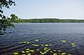
View over the lake


Web links
Individual evidence
- ↑ VISS Vatteninformationssystem Sverige. Retrieved May 25, 2018 (Swedish).
- ↑ Glenn G. Larsson: Stråkenleden - vandring - Mullsjö kommun. Retrieved May 25, 2018 (Swedish).
- ↑ iFiske.se - Stråkens FVOFStråken, a 25 km long and 100 - 500 m wide lake, which is about 20 km to the west of the southern part of Lake Vättern. The lake is a Spaltensee with a maximum ... Retrieved on May 25, 2018 (German).