Sultanpur (Uttar Pradesh)
| Sultanpur | ||
|---|---|---|
|
|
||
| State : |
|
|
| State : | Uttar Pradesh | |
| District : | Sultanpur | |
| Location : | 26 ° 16 ' N , 82 ° 4' E | |
| Height : | 100 m | |
| Residents : | 107,640 (2011) | |
| Website : | www.sultanpurnpp.in | |
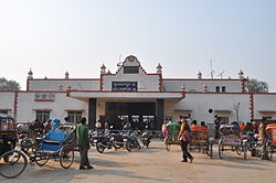
| Sultanpur train station | ||
Sultanpur ( Hindi : सुल्तानपुर , Urdu : سلطان پور; Sultānpur [ sʊlˈtɑːnpʊr ]) is a city in the northern Indian state of Uttar Pradesh with around 108,000 inhabitants (2011 census).
It is located 140 kilometers southeast of Lucknow and 100 kilometers north of Prayagraj on the right bank of the river Gomti in the eastern region of Awadh (Oudh) in Central Uttar Pradesh. The city is the administrative seat of the Sultanpur district .
According to local tradition, Sultanpur is said to have been located on the opposite bank of the Gomti and was named Kusabhavanpur. Kusabhavanpur was founded by the mythical figure Kusha, the son of the god Rama . One of the sultans of Delhi named Ala-ud-Din, whose historicity is not certain, is said to have destroyed Kusabhavanpur and founded the new city of Sultanpur.
The national highways NH 96 from Prayagraj to Faizabad and NH 56 from Lucknow to Varanasi cross in Sultanpur . The railway line from Prayagraj to Faizabad also runs through Sultanpur.

