Sulzbach (Rhine)
| Sulzbach | ||
|
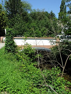
Oberdottinger Bridge in Ballrechte-Dottingen over the Sulzbach |
||
| Data | ||
| Water code | DE : 23352 | |
| location | South Baden , Baden-Wuerttemberg , Germany | |
| River system | Rhine | |
| Drain over | Rhine → North Sea | |
| source | at Rammelsberger Eck 47 ° 49 ′ 33 ″ N , 7 ° 45 ′ 52 ″ E |
|
| muzzle | near Hartheim - Weinstetten under the A5 into the Upper Rhine Coordinates: 47 ° 53 '46 " N , 7 ° 35' 26" E 47 ° 53 '46 " N , 7 ° 35' 26" E
|
|
| length | 17.4 km | |
| Small towns | Sulzburg , Heitersheim | |
The Sulzbach ( ) is a 17.4 km long right tributary of the Rhine . It forms the historical border between the Markgräflerland and the Breisgau .
Flood
On August 9, 2007, the Sulzbach in front of the town of Heitersheim reached a water level of almost six meters.
Several retention basins exist in its course. The one above Heitersheim is considered exemplary in its natural design. The latest with a volume of 40,000 m³ was built in 2010 as part of the renovation and modernization of an existing building above the city of Sulzburg .
Individual evidence
- ↑ Geoportal Baden-Württemberg ( information )
- ↑ badische-zeitung.de, October 29, 2010, opinion, letters to the editor , Werner Schäffner: The historical border is the Sulzbach (November 12, 2010)
- ↑ badische-zeitung.de, August 7, 2007, picture gallery, image 13: Southwest: floods and rain chaos ( memento from March 10, 2014 in the Internet Archive ) (November 12, 2010)
- ↑ badische-zeitung.de, October 21, 2010, Lokales, Sulzburg , Volker Münch: The work is right on schedule (November 12, 2010)
