Sutherlin
| Sutherlin | |
|---|---|
 Sutherlin Bank Building |
|
| Location in Oregon | |
| Basic data | |
| Foundation : | 1911 |
| State : | United States |
| State : | Oregon |
| County : | Douglas County |
| Coordinates : | 43 ° 23 ′ N , 123 ° 19 ′ W |
| Time zone : | Pacific ( UTC − 8 / −7 ) |
| Residents : | 6,669 (as of 2006) |
| Population density : | 494 inhabitants per km 2 |
| Area : | 13.7 km 2 (approx. 5 mi 2 ) of which 13.5 km 2 (approx. 5 mi 2 ) is land |
| Height : | 158.5 m |
| Postal code : | 97479 |
| Area code : | +1 (541) 459 |
| FIPS : | 41-71650 |
| GNIS ID : | 1127772 |
| Website : | www.ci.sutherlin.or.us |
| Mayor : | Joe Mongiovi |
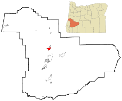
Sutherlin is a place in the southwest of the US state Oregon . It belongs to Douglas County and is located about 30 kilometers from Roseburg .
In 2004 there were 7256 inhabitants, an increase of 8.8 percent compared to the year 2000. This makes Sutherlin one of the fastest growing towns in southern Oregon. Nevertheless, Sutherlin is strongly linked to the larger neighboring town of Roseburg (approx. 20,000 inhabitants). The economy is still largely based on agricultural products. So the average annual income is around $ 40,000. The unemployment rate is 8 percent.
Sutherlin is surrounded by forests and mountain landscapes that are ideal for fishing and hunting. The place itself is located in one of the numerous valleys of the Coastal Mountain Range .
The National Park Service lists two structures and sites for Sutherlin on the National Register of Historic Places (as of January 11, 2019), the Stephens Community Historic District and the Sutherlin Bank Building .
Web links
Individual evidence
- ↑ Search mask database in the National Register Information System. National Park Service , accessed January 11, 2019.
