Sveta Nedelja
| Sveta Nedelja | ||
|
||
|
|
||
| Basic data | ||
|---|---|---|
| State : |
|
|
| County : |
|
|
| Area : | 52.6 km² | |
| Residents : | 18,059 (2011) | |
| Population density : | 343 inhabitants per km² | |
| Telephone code : | (+385) 01 | |
| Postal code : | 10 431 | |
| License plate : | ZG | |
| Structure and administration (status: 2013, cf. ) |
||
| Community type : | city | |
| Mayoress : | Drago Prahin ( HDZ ) | |
| Postal address : | Trg Ante Starčevića 5 10 431 Sveta Nedelja |
|
| Website : | ||
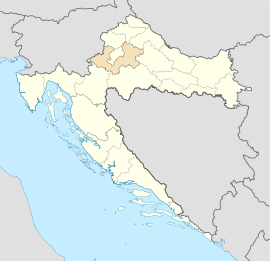
Sveta Nedelja is a city in Croatia , which is located in the Zagreb County . It is located around six kilometers east of Samobor and around 17 kilometers west of the city center of Zagreb . It extends over 65 km² and consists of 14 districts.
The city has its own exit on the A3 motorway , which connects Zagreb with Slovenia .
Individual evidence
- ^ Grad Sveta Nedelja: Kultura i povijest. (No longer available online.) City of Sveta Nedelja, archived from the original on May 25, 2012 ; Retrieved July 28, 2012 . Info: The archive link was inserted automatically and has not yet been checked. Please check the original and archive link according to the instructions and then remove this notice.
Web links
- Official website of the city (Croatian)

