Swyre Head (Lulworth)
| Swyre Head | ||
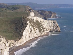
 Bat's Head and right behind it Swyre Head |
||
| Geographical location | ||
|
|
||
| Coordinates | 50 ° 37 '26 " N , 2 ° 17' 6" W | |
| Waters 1 | English Channel | |
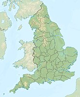
Swyre Head is located at West Lulworth and Lulworth Cove on the English Channel coast of Dorset in the south of England . It is located directly west of Durdle Door , about two kilometers from West Lulworth and 14 kilometers west of Swanage . It is just east of Bat's Head and about eight miles east of Weymouth .
It bears the same name as Swyre Head , the highest point of the Purbeck Hills and the Isle of Purbeck . The two Swyre Heads are about 18 kilometers apart.
geology
The cliffs are made of chalk and are part of the extensive southern English chalk formation . They are very steep and accessed by a footpath called the South West Coastal Path . Despite its steep climbs, the trail is very popular and the scenery is spectacular. The area between Swyre Head and Durdle Door is known as the "scratchy bottom" because of its ruggedness.
A stretch of coastline stretches from Orcombe Point in the west to Old Harry Rocks in the east, which was the first natural landscape in England to be declared a UNESCO World Heritage Site. Swyre Head is part of the Jurassic Coast , one of the natural wonders of the world and known for its fossils .
