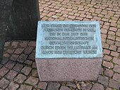
Goethestrasse synagogue
The Goethestrasse Synagogue in Kiel existed from 1909 to 1938.
location
The property on which the synagogue once stood is east of the Schreven Park (then Hohenzollern Park) in the Kiel district of Schreventeich on the corner of Goethestrasse and Humboldtstrasse. It was directly adjacent to the school premises of the former Reform- Realgymnasium on Knooper Weg / corner of Humboldtstraße (today Gymnasium Humboldt-Schule ) and was opposite the Humboldtstraße power station, which still exists today .
history
The first Jews settled in Kiel at the end of the 17th century. In 1782, the city's first Jewish prayer house was built at Kehdenstrasse 12, a former university coffee house . In 1869 the community moved into a three-story synagogue on Haßstrasse, where part of the former ground floor is still in ruins today. When it became too small, the city bought a plot of land on the corner of Goethestrasse and Humboldtstrasse at a preferential price of 13,425 marks . There, the Jewish community had a large synagogue built according to plans by the Kiel architect Johann Theede , which was opened on January 2, 1910 in the presence of the Lord Mayor Paul Fuß and the chief rabbi from Wandsbek .
The community had financed the new synagogue from its own resources, donations and the proceeds from the sale of the property in Haßstrasse. It became a monumental four-winged building, the central structure of which was closed off by an imposing dome. The large two-storey assembly room could seat around 400 people. In addition to this, the synagogue also housed a religious school and was a center of Jewish life in Kiel, where various clubs and associations had their premises. After the inner courtyard was roofed over in 1926, a standing and bathtub was installed there.
During the Reichspogromnacht of November 9-10, 1938, following instructions from the then Kiel Police President Joachim Meyer-Quade, members of the SS and SA under the supervision of SA leader Carsten Volquardsen looted and devastated the synagogue and then set it on fire. In 1939 the city bought the ruins and land from the Jewish community, the value of which was estimated at around 200,000 RM before the destruction , for 20,000 RM. The demolition work, which began soon after, dragged on until November 1940, so that the originally planned construction of a residential and commercial building at this point no longer came about.
To commemorate the destruction of the synagogue, a bronze plaque was attached to the facade of a residential building built there in the 1960s in 1968. In 1989 a memorial was erected on the corner of Goethestrasse and Humboldtstrasse , designed by the Hamburg sculptor Doris Waschk-Balz . This integrated the older plaque into her work. Every year on November 9th or on the anniversaries of the inauguration of the synagogue, the citizens of Kiel organize irregular commemoration ceremonies here.
In 1933 only about 0.3% of the Kiel population were Jews. And yet the approx. 600 Jews living there at that time formed the second largest Jewish community in Schleswig-Holstein after Altona . Few of them remained after the end of World War II; In 1961 only 27 lived in the city. Today around 550 Jews, mainly from Eastern Europe, form two independent parishes in Kiel, each of which has its own house of prayer. The synagogue of the Jewish community for Kiel and the region is located on Wikingerstraße in the Gaarden-Ost district . The prayer house of the Jewish community in Kiel was located on Eckernförder Straße. Instead of this, a new one was moved into on August 31, 2008 in Jahnstrasse, just a few hundred meters from the location of the former synagogue, the lease of which expired in early 2019. The community has been using a building on Waitzstrasse as a synagogue since summer 2019 .
See also
literature
- Press office of the Supply and Transport Kiel GmbH (VVK) (ed.): Documentation on the history of the Kiel synagogue and the memorial on Goethestrasse 13. Kiel 1992.
Web links
Footnotes
- ^ Humboldt School Kiel: Data on the history of the school ( memento from June 1, 2011 in the Internet Archive ) on: humboldt-kiel.lernnetz.de
- ↑ The old synagogue is to be upgraded . In: Kiel News . on: spd-net-sh.de , August 3, 2004, accessed April 10, 2011.
- ↑ a b c Martina Drexler: Symbol for Jewish life in Kiel . on: kn-online.de , January 12, 2010, accessed April 10, 2011.
- ↑ Eckhard Colmorgen (Red.): The Jewish community. In: Kiel under National Socialism. Materials and documents. 2nd Edition. Ed .: Asche Process Working Group , Kiel 1994, p. 67ff. ( Reader ); Digitized at the working group for research into National Socialism in Schleswig-Holstein e. V. (AKENS), accessed on April 10, 2011.
- ↑ a b c Christa Geckeler: Kiel Memorial Days: November 9, 1938 - Kiel November Pogrom . I: kiel.de , accessed on December 5, 2017.
- ^ Press office of the Supply and Transport Kiel GmbH (VVK) (Ed.): Documentation on the history of the Kiel synagogue and the memorial on Goethestrasse 13. Kiel 1992.
- ↑ Greetings from Mayor Cathy Kietzer on the occasion of the lecture event “100 years ago: Inauguration of the Kiel synagogue”. ( Memento of October 14, 2011 in the Internet Archive ) (PDF file; 36 kB).
- ↑ Return to the historical location ( Memento of the original from January 29, 2016 in the Internet Archive ) Info: The archive link was inserted automatically and has not yet been checked. Please check the original and archive link according to the instructions and then remove this notice. . (PDF file; 1.96 MB). In: Jewish Schleswig-Holstein. 3rd edition. July 2008, p. 8, accessed April 10, 2011.
- ↑ Heike Linde-Lembke: Two synagogues on the fjord. May 29, 2019, accessed December 11, 2019 .
Coordinates: 54 ° 19 ′ 37.2 ″ N , 10 ° 7 ′ 32.9 ″ E


