Synyuchyn Brid
| Synyuchyn Brid | ||
| Синюхин Брід | ||

|
|
|
| Basic data | ||
|---|---|---|
| Oblast : | Mykolaiv Oblast | |
| Rajon : | Pervomaysk Raion | |
| Height : | 99 m | |
| Area : | 0.3 km² | |
| Residents : | 1,708 (2001) | |
| Population density : | 5,693 inhabitants per km² | |
| Postcodes : | 55243 | |
| Area code : | +380 5161 | |
| Geographic location : | 48 ° 9 ' N , 30 ° 49' E | |
| KOATUU : | 4825486301 | |
| Administrative structure : | 1 village | |
| Address: | вул. Центральна буд. 14 55243 с. Синюхин Брід |
|
| Website : | City council website | |
| Statistical information | ||
|
|
||
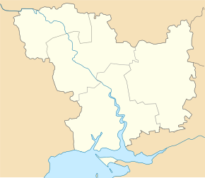
Synjuchyn Brid ( Ukrainian Синюхин Брід ; Russian Синюхин Брод Sinjuchin Brod ) is a village in the northwest of the Ukrainian Oblast of Mykolaiv with about 1700 inhabitants (2001).
The village, founded in 1755, arose at a ford on the left bank of the Synjucha River , a 111 km long tributary of the Southern Bug .
Synjuchyn Brid is the only village of the same district municipality in northern Rajon Pervomaisk and is located at an altitude of 99 m , 14 km north of Rajonzentrum Pervomaisk and 170 km northwest of the Oblastzentrum Mykolaiv .
Territorial road T-12-19 runs east of the village .
Individual evidence
- ↑ a b local website on the official website of the Verkhovna Rada ; accessed on March 24, 2020 (Ukrainian)
- ↑ history Synjuchyn Brid in the history of the towns and villages of the Ukrainian SSR ; accessed on March 24, 2020 (Ukrainian)
- ^ Website of the district council on the official website of the Verkhovna Rada; accessed on March 24, 2020 (Ukrainian)

