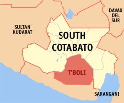
T'Boli
| Municipality of T'Boli | ||
| Location of T'Boli in the South Cotabato Province | ||
|---|---|---|

|
||
| Basic data | ||
| Region : | SOCKSARGEN | |
| Province : | South Cotabato | |
| Barangays : | 25th | |
| District: | 2. District of South Cotabato | |
| PSGC : | 126316000 | |
| Income class : | 1st income bracket | |
| Households : | 12,679 May 1, 2000 census
|
|
| Population : | 91,453 August 1, 2015 census
|
|
| Coordinates : | 6 ° 3 ' N , 124 ° 55' E | |
| Postal code : | 9513 | |
| Mayor : | Ernesto Bibay Manuel | |
| Website: | www.tboliscot.gov.ph | |
| Geographical location in the Philippines | ||
|
|
||
T'Boli is a Philippine municipality in the province of South Cotabato . It has 91,453 inhabitants (August 1, 2015 census). The municipality is located in the Daguma Mountains , in which the active Parker volcano and the Maughan Lake are located in the municipality.
Barangays
T'boli is politically divided into 25 barangays .
|
|

