Coronadal City
| City of Koronadal | ||
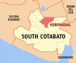
| Location of Koronadal City in the South Cotabato Province | ||
|---|---|---|

|
||
| Basic data | ||
| Region : | SOCKSARGEN | |
| Province : | South Cotabato | |
| Barangays : | 27 | |
| District: | 2. District of South Cotabato | |
| PSGC : | 126306000 | |
| Income class : | 3rd income bracket | |
| Households : | 27,623 May 1, 2000 census
|
|
| Population : | 174,942 August 1, 2015 census
|
|
| Population density : | 631.6 inhabitants per km² | |
| Area : | 277 km² | |
| Coordinates : | 6 ° 13 ′ N , 125 ° 4 ′ E | |
| Postal code : | 9506 | |
| Area code : | +63 83 | |
| Mayor : | Fernando Q. Miguel ( Lakas CMD / Kampi ) | |
| Website: | www.koronadal.gov.ph | |
| Geographical location in the Philippines | ||
|
|
||
Koronadal (officially: City of Koronadal ), also known by the locals as Marbel , is a city in the Philippines and is located in the province of South Cotabato on the island of Mindanao .
It is on the one hand the district center of the Philippine District XII SOCCSKSARGEN , on the other hand the capital of the province of South Cotabato .
Koronadal City is also an educational, administrative, economic and commercial center of this province, as well as the neighboring province of Sultan Kudarat .
Origin of name
The word Koronadal is believed to be derived from two words in the B'laan language. The first part comes from the word koren or Kolon , which means Cogon grass , a hardy grass species that grows in the Philippines . The second part consists of the word nadal or datal , which means flat land . Together it describes the place where the locals settled, a flat grassland .
Another name of the city is Marbel . This also comes from the dialect B'laan and is derived from the word Marb-E and means cloudy water . The name probably refers to a nearby river known today as the Marbel River. It is quite possible that this name was originally used for the place.
geography
Koronadal is located in the northeastern part of the South Cotabato Province . The city is bounded by the municipality of Tantangan in the northwest and the municipality of Lutayan in the province of Sultan Kudarat in the northeast, by the municipality of Banga in the southwest and in the southeast by the municipalities of Tupi and Tampakan.
Koronadal is a fertile valley bounded by the Roxas Mountains in the southwest and the Quezon mountain range in the northeast.
The Roxas Mountains stretch from Baranggay Saravia in the southeast to Morales in the north and break through the districts of Carpenter Hill, San Isidro, Sta. Cruz, Mambucal and Poblacion. The Quezon mountain range stretches along the barangays of San Jose, Mabini, Esperanza, Cacub and Topland.
The city is 56 km away from General Santos City and 136 km from Cotabato City .
Demographics and language
The main dialect of the residents of Koronadal City is Hiligaynon (Ilonggo), which is spoken by 69.58% of the population. This is due to the fact that the Marbel settlement was founded by immigrants from the Ilonggos ethnic group from the northern Visayas . Other popular dialects are Cebuano and Ilocano.
There are various religious groups in the city. Most of the residents are Roman Catholic, followed by Protestant groups and the Iglesia ni Cristo .
There is also a mixture of Muslim and indigenous ethnic groups such as the B'laan and the T'boli in and around the city.
Barangays
Koronadal City is politically divided into 27 barangays .
|
|
history
In the past the area was populated by the ethnic groups of the B'laans and the Maguindanaos. Later immigrants from the Visayas settled in the area and founded the place Marbel. When the place became Koronadal is not known.
The settlement of Koronadal was granted the status of an administrative municipality on August 18, 1947 by Executive Order No. 82. When on July 18, 1966, Republic Act No. In 4849 the province of South Cotabato was formed, the city quickly received the approval to accommodate the administrative seat of the new province.
The local area at that time was comparable to the province of Bata-an and includes today's communities Tampakan, Tupi, Banga, Lake Sebu, Surallah, T'Boli, Sto. Niño, Norala and Isulan.
Koronadal was granted the city charter under Republic Act 8803 on October 8, 2000. In 2003, it was named the '' Most Competitive City '' in the Filipino Smallest Cities category.
By Executive Order no. 304 of 30 March 2004 Koronadal the seat of the district government of the district Soccsksargen , consisting of the provinces of South Cotabato , Cotabato , Sultan Kudarat and the cities of Kidapawan City , Tacurong , Cotabato City and General Santos City is .
climate
According to weather data, the average temperature in the city is 27.07 ° C. The warmest months are from April to October, while December to January is rather cool.
Rainfalls occur more or less all year round. The city is relatively protected from tropical storms by the nearby mountain ranges.
economy
As the administrative center of the new District XII, the city became an important hub of trade, industry and economy.
Koronadal City is primarily an agricultural area. It is the heart of rice and grain cultivation and a center of trade in raw and processed products.
But fruits are also a distinct source of income for the residents of Koronadal City.
Web links
- Official website for Koronadal City
- WOW - Philippines Koronadal City ( Memento from December 18, 2008 in the Internet Archive )
