
Cycling map
Bike maps are part of the mappae mundi and are characterized by the circular representation of the world known at the time. For this reason, the TO cards , which were widespread in the Middle Ages , can be seen as a modification of the cycling maps.
General
According to the Bible (and also ancient sources) the known world was presented "in the earth " (O-shape). Since the work was carried out by monks, such representations are also called monk cards .
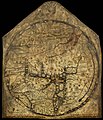
The cards are almost always faces east (east is at the top), in the top half of the circle is Asia and usually also the paradise , below are Europe and Africa . With the establishment of the Christian Kingdom of Jerusalem , the maps change in that the Holy Land occupies the center of the world.
The famous world map by Andreas Walsperger can be called a bike map.
TO cards
Isidore, Bishop of Seville , tried with his work Etymologiae to collect and preserve all knowledge from antiquity. In the de natura rerum chapter , the viewer will find a map of the world on which the earth is surrounded by the ocean . Two rivers, Don and Nile , and the Mediterranean Sea divide the land mass into three continents, Europe , Africa and Asia .
In one passage from the scholar it says:
“Orbis a rotunditate circuli dictus, quia sicut rota est […] Undique enim Oceanus circumfluens eius in circulo ambit fines. Divisus est autem trifarie: e quibus una pars Asia, altera Europe, tertia Africa nuncupatur. "
“The [earth] circle is named after the roundness of the circle [...] That is why the ocean flowing around it changes within the boundaries of a circle. It is in turn divided into three parts: one part is called Asia, the other Europe, the third Africa. "
The letter T, Tau , is also a symbol of the universe . The Florentine Leonardo Dati writes the following about the division into three parts in his poem La Sfera :
"Un T dentro a uno O monstra il disegno Come in tre parte fu diviso il mondo"
"A T within an O shows us the picture of how the earth was divided into three areas."
The T-shaped trisection and the circular, i.e. O-shaped representation of the earth are responsible for the designation "TO cards". Often they were inserted into psalteries as small text images . With the crusades from 1100, however, the contents of the maps became more extensive and correspondingly larger representations were created.
Pictures of famous cycling maps
Hereford map ,
13th century
Ebstorf world map ,
no later than 1300
Cycling map
“after Isidore of Seville”,
from Jean Mansel ,
La Fleur des Histoires, manuscript, Valenciennes,
1459–1463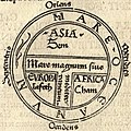
Cycling map from Isidore von Sevillas Etymologiae , first print Günther Zainer , 1472

Scheme based on Meyers Konversationslexikon, 1888, revised (geosted as in the Middle Ages)

Fra Mauros world map from 1459


.png)

literature
- Anna-Dorothee von den Brincken : The world view of the Irish sailor-saint Brendan in the view of the 12th century. In: Cartographica Helvetica . No. 21, 2000, pp. 17-21, ( digitized ).
- Anna-Dorothee von den Brincken: Mappa mundi and Chronographia. Studies on the imago mundi of the occidental Middle Ages. In: German Archive for Research into the Middle Ages . Vol. 24, 1968, pp. 118-186, ( digitized version ).
- Evelyn Edson, Emilie Savage-Smith, Anna-Dorothee von den Brincken : The medieval cosmos. Maps of the Christian and Islamic world. Primus, Darmstadt 2005, ISBN 3-89678-271-1 .
- Brigitte English: Ordo orbis terrae. The world view in the Mappae mundi of the early and high Middle Ages (= Orbis mediaevalis. 3). Academy, Berlin 2002, ISBN 3-05-003635-4 (also: Hamburg, University, habilitation paper, 2000).
- Hartmut Kugler: High medieval world maps as historical images. In: Hans-Werner Goetz (Hrsg.): High medieval historical consciousness in the mirror of non-historiographical sources. Akademie-Verlag, Berlin 1998, ISBN 3-05-003188-3 , pp. 179-200.
- Joachim G. Leithäuser : Mappae mundi. The spiritual conquest of the world. Safari, Berlin 1958, ( DNB 452795125 ).
- Claudius Sieber-Lehmann : Albrecht von Bonstetten's geographical representation of Switzerland. In: Cartographica Helvetica. No. 16, 1997, pp. 39-46, ( digitized version ).
See also
- Glyph ♁ as a symbol for earth or church
Web links
Individual evidence
- ↑ Hartmut Kugler: High medieval world maps as historical images. In: Goetz Hans-Werner (Hrsg.): High medieval historical consciousness in the mirror of non-historical sources. Berlin 1998, pp. 179-200, here p. 179.
- ^ Joachim Gustav Leithäuser: Mappae mundi. The spiritual conquest of the world . Berlin 1958, pp. 61-62.
- ↑ Anna-Dorothee von den Brincken: Mappa mundi and Chronographia. Studies on the imago mundi of the occidental Middle Ages. In: German Archive for Research into the Middle Ages. Vol. 24, 1968, pp. 118-186, here p. 131.