Takutea
| Takutea | ||
|---|---|---|
| Profile of Takutea | ||
| Waters | Pacific Ocean | |
| Archipelago | Cook Islands | |
| Geographical location | 19 ° 48 '47 " S , 158 ° 17' 39" W | |
|
|
||
| length | 1.8 km | |
| width | 1 km | |
| surface | 1.22 km² | |
| Residents | uninhabited | |
| Map of Takutea | ||
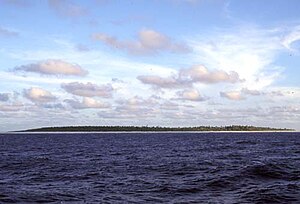
Takutea is a small, uninhabited island in the southern Cook Islands in the South Pacific .
It is located 21 kilometers northwest of Atiu and administratively belongs to Atiu. Takutea measures about 1.2 km² in area. The island was discovered by James Cook on January 4th, 1777 . Landings at Takutea are considered dangerous and are only possible in the northwest. Today the island is a nature reserve , the Takutea Wildlife Sanctuary, in which seabirds such as the red-tailed tropical bird and palm thieves , a type of crustacean also known as coconut crabs , are located.
Takutea is administratively considered part of Atiu, the closest atoll at a distance of 13 miles. The island belongs equally to all inhabitants of Atiu and is not assigned to a specific village on Atiu.
literature
- Gerald McCormack: Takūtea Wildlife Sanctuary, Cook Islands. South Pacific Regional Environment Program, 1994.
Web links
- Takutea, Cook Islands. www.cookislands.org.uk, accessed December 9, 2017 .
Individual evidence
- ↑ Alphons MJ Kloosterman: Discoverers of the Cook Islands and the Names they Gave: 15. Takutea . Cook Islands Library and Museum, 1976, p. 53 (English, victoria.ac.nz [accessed December 9, 2017]).
- ↑ Takutea Wildlife Sanctuary. In: birdlife.org. datazone.birdlife.org, accessed December 9, 2017 .


