Nassau (Cook Islands)
| Nassau | ||
|---|---|---|
| Nassau satellite image | ||
| Waters | Pacific Ocean | |
| Archipelago | Cook Islands | |
| Geographical location | 11 ° 34 '4 " S , 165 ° 24' 25" W | |
|
|
||
| length | 1.7 km | |
| width | 1 km | |
| surface | 1.3 km² | |
| Highest elevation | 9 m | |
| Residents | 73 (2011) 56 inhabitants / km² |
|
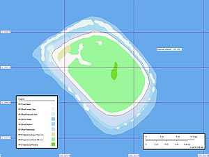
| Map of Nassau | ||
Nassau or Motungongau is an island in the northern group of the Cook Islands in the South Pacific .
geography
The island is located about 90 km southeast of the neighboring island of Pukapuka and has an approximately oval shape, about 1.7 km long and about 1.0 km wide. Nassau is surrounded by a shallow water zone up to 1.3 km wide with a 90 to 130 m wide coral reef and rises 9 m from the ocean. The island is densely overgrown with coconut palms and has 73 inhabitants who live in the only settlement in the northwest. There is no runway, but there are irregular ship connections to Pukapuka .
history
A legend of Nassau was (probably in the 17th century) of Pukapuka populated, its inhabitants regarded it as their property from. The Pukapukans named the island Te Nuku-o-Ngalewu (Land of Ngalewu), after a chief who defended them against an attack by a warrior named Tima from Aitutaki . The theme reef between Nassau and Pukapuka is named after this. But contact between the two islands broke off "at the time when the great quarrel between the gods made seafaring dangerous". The population died out or left the island and it was named Te Motu-ngaongao (deserted island).
For the European world, Nassau was discovered on May 12, 1804 by the French captain Louis R. Coutance, who named the island after his ship Adèle . Twenty years later, Nassau was renamed Lydra Island, then Ranger Island after the London whaler Ranger . Captain Elihu Coffin of the American whaler Mary Mitchell from Nantucket gave it the name Mitchell Island in 1834. Captain Joseph Paddack of the whaler Audley Clark from Newport (Rhode Island) sighted the island on December 28, 1836 and named it New-Port Island. He described it as densely forested and uninhabited.
The island got its current name from the American whaling ship Nassau from New Bedford (Massachusetts) whose captain John D. Sampson sighted it in March 1835. Nassau was annexed to Great Britain in 1892 . The island was devastated in February 2005 by cyclone "Percy".
literature
- Edwin H. Bryan, Jr .: American Polynesia and the Hawaiian Chain; Honolulu . Hawaii 1942 (Rev. ed.)
- Henry Evans Maude: Post-Spanish discoveries in the Central Pacific , in: The Journal of the Polynesian Society , Vol. 70; Auckland 1961, pp. 67–111 ( online )
- Edouard A. Stackpole: The sea-hunters: the New England whalemen during two centuries, 1635-1835. Philadelphia [u. a.]: Lippincott, 1953
Web links
- Information about Nassau (English)
- Information and pictures (English)
Individual evidence
- ↑ a b Nassau - A lonely garden of Eden . In: The Cook Islands . John Roberts , accessed October 23, 2016 .


