Mauke (island)
| Muck | ||
|---|---|---|
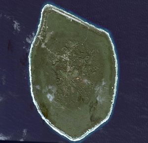
| Satellite image from Mauke | ||
| Waters | Pacific Ocean | |
| Archipelago | Cook Islands | |
| Geographical location | 20 ° 9 '40 " S , 157 ° 20' 28" W | |
|
|
||
| length | 6.5 km | |
| width | 4.2 km | |
| surface | 18 km² | |
| Highest elevation | 30 m | |
| Residents | 650 (2004) 36 inhabitants / km² |
|
| main place | Nukuao (Nukutao) | |
| Topographic map | ||
Mauke (outdated Akatokamanava or Parry's Island ) belongs to the southern archipelago of the Cook Islands .
It is the easternmost of the southern Cook Islands and is located about 240 km northeast of the main island of Rarotonga . Mauke is a typical upscale atoll with a central volcanic plateau , which is around 30 meters above sea level at its highest point and is surrounded by a dead coral reef . The island has a length of 6.5 km, a width of about 4 km and an area of about 18 km². In 2004 it had about 650 inhabitants.
There are no paved roads on Mauke, instead they are covered with "sand" made from ground coral. The island does not have a port, but has a runway ( IATA airport code : MUK, ICAO : NCMK) to which Air Rarotonga flies several times a week .
The name of the island is derived from the term "ma Uke" (island of the Uke) and thus refers to the mythical first settler Uke from 'Avaiki . The first European on Mauke was the missionary John Williams who visited the island on July 23, 1823 with the Endeavor (not to be confused with James Cook 's ship of the same name). The British flag was first hoisted on November 1, 1888 by the crew of HMS Hyacinth, and Mauke remained a British protectorate until it was annexed in 1901 and placed under New Zealand administration.
structure
Mauke is divided into four traditional districts. Vaimutu and Makatea are not subdivided further and each correspond to a taper . Ngatiarua and Areora are divided into 6 and 3 tapers, respectively. That makes a total of 11 tapers for the entire island:
- Ngatiarua District (north, divided into 6 tapers)
- Vaimutu District (east, corresponds to a tapere)
- Areora District (south, divided into 3 tapers)
- Makatea District (west, corresponds to tapere)
Almost all the villages are in the interior of the island. Nukutao is the main town. The village near the landing site in the northwest is Kimiangatau.
swell
- Maps on evs-islands.com (English)
- Soil map of Mauke
Individual evidence
- ↑ Archived copy ( memento of the original from July 30, 2012 in the Internet Archive ) Info: The archive link was inserted automatically and has not yet been checked. Please check the original and archive link according to the instructions and then remove this notice. Cook Islands GeoCMS
- ↑ Archived copy . Archived from the original on July 9, 2007. Retrieved May 1, 2009.
- ^ Naval Intelligence Division: Pacific Islands. Volume II: Eastern Pacific, 1943, p. 545


