Rakahanga
| Rakahanga | ||
|---|---|---|
| Satellite photo of Rakahanga | ||
| Waters | Pacific Ocean | |
| archipelago | Cook Islands | |
| Geographical location | 10 ° 2 ′ S , 161 ° 5 ′ W | |
|
|
||
| Number of islands | 9 | |
| Main island | Rakahanga | |
| Land area | approx. 4 km² | |
| Residents | 77 (2011) | |
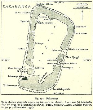
| Map (1943) | ||
Rakahanga (other names: Gente Hermosa , La del Peregrino , Rierson's Island or Grand Duke Alexander Island ) is a remote atoll in the Cook Islands in the Pacific Ocean . The atoll is 1250 km from the capital of the Cook Islands, Avarua on Rarotonga , and 1110 km south of the equator . The closest island is Manihiki , 38 km away , also in the south.
The atoll consists of two main islands and seven motu (reef islands) in the lagoon . In the east these are: Akaro , Motu Ngangle , Huananul , Motu Mahuta and Motu Okakara ; on the southwest side is the island of Te Kainga and the widest passage into the lagoon.
The islands are only 4 km² and are so low that sea level rise poses a serious threat from global warming. In 2006 141 people inhabited the island.
history
It is stated that Ferdinand Magellan discovered the island for Europeans in 1521, but this is not supported by historians of the island's history. One of the last great voyages of discovery by the Spaniards under the command of Pedro Fernández de Quirós reached the island on March 2, 1606. In a description of the trip he wrote: “The land is divided among many owners and planted with a certain root, which is their bread have to be. The rest of the island is a large, dense palm grove that is the native foodstuff. Around 500 inhabitants were seen gathered on the coast. "
A Franciscan brother who was traveling with him was so amazed that he named the island gente hermosa ("island of beautiful people"). De Quiros describes the locals as "the most beautiful white and elegant people we met during the trip".
In 1854 Rakahanga was proselytized by missionaries from the London Missionary Society who came from Rarotonga.
The island was claimed for the United States under the Guano Islands Act of 1856 . This claim was officially assigned to New Zealand in a treaty between the USA and New Zealand in 1980 .
Commander AC Clarke of the Doterel class belonging sloop HMS Espiegle declared the island on August 9, 1889 British protectorate . It was considered part of New Zealand in 1901.
nature
Numerous palm thieves live in the lagoon , the outer reef offers good conditions for fishing, and numerous sea turtles also live here . A tuna fishing competition is held every January , with boats landing more than 200 fish a day.
The island is densely overgrown. Large breadfruit trees line the village paths and coconut palms and pandanus trees flourish. The women make hats, mats and baskets from the fibers of the leaves of the pandanus tree.
The island is very difficult to get to, only by boat from Manihiki or with an occasional inter-island boat.
The local language is Rakahanga-Manihiki .


