Tallo (river)
| Tallo | ||
|
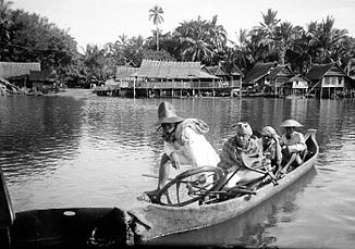
Residents paddle a boat across the river to the village of Tallo (1920) |
||
| Data | ||
| location | Sulawesi Selatan , Indonesia | |
| River system | Tallo | |
| source | near Mount Bawakaraeng 5 ° 13 ′ 30 ″ S , 119 ° 38 ′ 0 ″ E |
|
| muzzle | at Makassar in the Strait of Makassar Coordinates: 5 ° 6 ′ 15 " S , 119 ° 26 ′ 55" E 5 ° 6 ′ 15 " S , 119 ° 26 ′ 55" E
|
|
| length | 75 km | |
| Communities | Makassar, Gowa | |
| Ports | Paotere | |
The Tallo ( Indonesian Sungai Tallo ) is a 10 kilometer long river in the southwest half of the island of Sulawesi . The catchment area has an area of about 150 square kilometers.
The river has its source near the 2833 meter high mountain Bawakaraeng and runs through the Gowa district to the northern part of the port city of Makassar , where it flows into the Makassar Strait . At the mouth of the river used to be the center of the kingdom of the same name, Tallo , which reduced its depth due to extensive agriculture.
