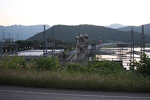
Tha Thung Na dam
| Tha Thung Na dam | ||
|---|---|---|
| location | ||
|
|
||
| Coordinates | 14 ° 14 ′ 1 ″ N , 99 ° 14 ′ 9 ″ E | |
| country |
|
|
| place | Province Kanchanaburi | |
| Waters | Khwae Yai | |
| Height upstream | 59.7 m | |
| power plant | ||
| owner | EGAT | |
| operator | EGAT | |
| construction time | 1977 to 1982 | |
| Start of operation | 1981 | |
| technology | ||
| Bottleneck performance | 38 megawatts | |
| Standard work capacity | 140 million kWh / year | |
| Turbines | 2 × 19 MW | |
| Others | ||
The dam Tha Thung Na is a dam with hydroelectric power plant in the district of Mueang Kanchanaburi Province Kanchanaburi , Thailand . It dams the Khwae Yai to a reservoir.
The dam is used to generate electricity. Construction began in December 1977; it was inaugurated in April 1978. The power plant went into operation in 1981. The dam is owned by the Electricity Generating Authority of Thailand (EGAT) and is also operated by EGAT.
Barrier structure
The barrier structure is a stone embankment dam with a height of 30 m. The length of the dam crest is 840 m; their width is 8 m. The weir system with the five weir fields and the machine house are on the left side of the river.
Reservoir
With a maximum storage target of 59.7 m, the reservoir holds around 55 million m³ of water. The reservoir also serves as a lower basin for the Si Nakharin pumped storage power plant .
power plant
The installed power of the power plant is 38 MW with two turbines . The annual production is 140 million kWh .
See also
Web links
Individual evidence
- ↑ a b c d Tha Thung Na Hydroelectric Power Plant Thailand. Global Energy Observatory, accessed May 20, 2020 .
- ↑ a b c d Tha Thung Na Dam. Electricity Generating Authority of Thailand (EGAT), accessed May 20, 2020 .

