
Ulldecona dam
| Ulldecona dam | |||||
|---|---|---|---|---|---|
 |
|||||
|
|||||
|
|||||
| Coordinates | 40 ° 41 ′ 0 ″ N , 0 ° 13 ′ 35 ″ E | ||||
| Data on the structure | |||||
| Lock type: | dam | ||||
| Construction time: | 1967-1985 | ||||
| Height of the barrier structure : | 54 m | ||||
| Base width: | 180 m | ||||
| Data on the reservoir | |||||
| Altitude (at congestion destination ) | 477 msnm | ||||
| Water surface | 8.17 km² | ||||
| Reservoir length | 3 km | ||||
| Storage space | 11 million m³ | ||||

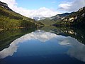
The Ulldecona dam ( Valencian Embassament d'Ulldecona or Pantà d'Ulldecona ) is located in the area of the municipality of La Pobla de Benifassà in the Comarca Baix Maestrat in the north of the province of Castellón of the Comunitat Valenciana east of the Cistercian monastery of Benifassà .
It is located eight kilometers northwest of the town of La Sénia at the meeting of three Barranco gorges, namely the Barrancos with the names Fou, Teulatí (or La Tenalla) and Pobla. Construction began in 1967, completion took place in 1985 and the financing was provided by farmers from Ulldecona on the Catalan bank of the Riu de la Sénia on an area of 817 hectares with a capacity of 11 million m³. The weight dam is 54 m high and 180 m wide.
The reservoir belongs to the Júcar Water Association.
The Ulldecona dam is a tourist destination in spring, summer and autumn. There are accommodation and restaurants, as well as boat and pedal boat rentals. The lake offers a view of the surrounding limestone mountains. The abandoned village of Malagraner lies on the north-west bank .
gallery

Summer view

Winter fog
Embassament d'Ulldecona


Web links
Individual evidence
- ↑ Ulldecona dam . In: La Senia . Caminant pel cel. March 22, 2018. Retrieved May 21, 2019.
- ↑ http://www.turismeulldecona.com/cont_quevisitar.php?id=3 ( Page no longer available , search in web archives ) Info: The link was automatically marked as defective. Please check the link according to the instructions and then remove this notice.