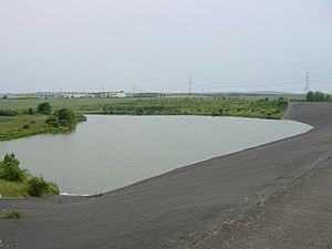
Vieselbach dam
| Vieselbach dam | |||||||||
|---|---|---|---|---|---|---|---|---|---|
| Vieselbach reservoir and dam with asphalt concrete sealing | |||||||||
|
|||||||||
|
|
|||||||||
| Coordinates | 50 ° 58 '39 " N , 11 ° 8' 45" E | ||||||||
| Data on the structure | |||||||||
| Construction time: | -1982 | ||||||||
| Height above foundation level : | 20 m | ||||||||
| Building volume: | 14th 600 m³ | ||||||||
| Crown length: | 405 m | ||||||||
| Data on the reservoir | |||||||||
| Water surface | 17 ha | ||||||||
| Storage space | 0.87 million m³ | ||||||||
| Catchment area | 11 km² | ||||||||
The Vieselbach reservoir ( Vieselbach reservoir) is an agricultural reservoir and is located east of Erfurt between Erfurt-Vieselbach and Mönchenholzhausen near Hochstedt .
The dam is a damming of the Vieselbach and has changing water levels. In addition to irrigation, it also regulates the water level in the Vieselbach. The reservoir is a popular fishing spot.
The barrier structure is a 400 m long and 20 m high earth dam with an outer seal made of asphalt concrete on the water side . That is why the dam does not appear close to nature. The dam belongs to the Thuringian long-distance water supply .
See also
Web links
Commons : Vieselbach reservoir - collection of images, videos and audio files
- Thuringian long-distance water supply - dams of the operation center ( Memento from March 3, 2009 in the Internet Archive )
- Regional development plan of the local action group of the Weimarer Land district p. 16 ( Memento from February 2, 2006 in the Internet Archive ) (PDF file; 958 kB)

