Tanjurer
|
Tanjurer Танюрер |
||
|
|
||
| Data | ||
| Water code | RU : 19050000212119000120837 | |
| location | Chukchi Autonomous Okrug ( Russia ) | |
| River system | Anadyr | |
| Drain over | Anadyr → Bering Sea | |
| source | in the Chukotka highlands 67 ° 32 '4 " N , 177 ° 23' 29" E |
|
| muzzle | in the Anadyr coordinates: 64 ° 44 ′ 10 " N , 174 ° 18 ′ 43" E 64 ° 44 ′ 10 " N , 174 ° 18 ′ 43" E
|
|
| length | 482 km | |
| Catchment area | 18,500 km² | |
|
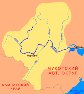
Location of the Tanjurer in the catchment area of the Anadyr |
||
The Tanjurer ( Russian Танюрер ) is a left tributary of the Anadyr in the Chukchi Autonomous Okrug in northeast Siberia .
The 482 km long river has its origin in the Chukotka highlands , north of the Pekulnei Mountains . It flows along the eastern edge of the Pekulnei Mountains in a south-southwest direction into the Anadyr lowlands , where it meets the Anadyr coming from the west north of Krasnoye Lake . The Tanjurer drains an area of 18500 km². In June the mean discharge of the Tanjurer near the mouth is 1160 m³ / s. The river freezes in November and is ice-free again in late May / early June. The lower reaches are navigable.
Individual evidence
- ↑ a b c Article Tanjurer in the Great Soviet Encyclopedia (BSE) , 3rd edition 1969–1978 (Russian)
- ↑ a b Tanjurer in the State Water Register of the Russian Federation (Russian)
- ↑ Tanjurer at the Tanjurer gauge - hydrographic data from R-ArcticNET
