Taung
| Taung | ||
|---|---|---|
|
|
||
| Coordinates | 27 ° 32 ′ S , 24 ° 47 ′ E | |
| Basic data | ||
| Country | South Africa | |
| northwest | ||
| District | Dr Ruth Segomotsi Mompati | |
| ISO 3166-2 | ZA-NW | |
| local community | Greater Taung | |
| Residents | 18,289 (2011) | |
Taung is a city in the Northwest Province of South Africa . It is halfway between Kimberley and Vryburg . In 2011, 18,289 inhabitants lived here. Taung means "place of the lion " in Setswana and was named after chief Tau of the BaTaung or Legoya tribe .
history
During apartheid, Taung had a specialized higher education school where the sons of chiefs and other traditional tribal leaders from the Batswana demographic group were trained for future administrative tasks. At the end of the training two degrees could be obtained. They were a low-level degree in administration and a full degree in administration and law.
Archaeological research

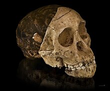
The place became internationally known after a worker from the Buxton quarry made a bone find in November 1924, which Raymond Dart described a few weeks later in the British journal Nature as the fossil skull of a prehistoric man . This first finding of an Australopithecus africanus was later referred to as the " child of Taung ". The fossil is now kept at Witwatersrand University in Johannesburg . There is a small memorial in the quarry.
In 2005 the site in the former Buxton quarry and some archaeological sites in the vicinity were added to the UNESCO list of world cultural heritage . In addition to Taung, the entry includes the sites in Gauteng, also known as the cradle of mankind, and Makapansgat near Mokopane .
More Attractions
Other tourist attractions are the Blue Pools climbing and picnic area in the quarry, the 150-hectare Boipelo reserve belonging to a hotel complex, the stone carvings of the San of Dinkwaneng near the village of Manthe and - east of Taung - the Mmabana Cultural Center with its range of local handicrafts.
economy
The region around Taung is characterized by farms. The northern foothills of the Vaalharts Water irrigation system extend to this point . The Taung Reservoir ("Taung Dam"), which was built between 1982 and 1984, is about 17 kilometers from the city center . It serves the water supply in the region and is used for tourism.
Web links
- Directions to the Taung Heritage Site (English)
- Fossil Hominid Sites of South Africa. Entry in the UNESCO World Heritage List (English)
Individual evidence
- ↑ 2011 census , accessed September 7, 2015
- ^ Department of Information (ed.): Multinational Development in South Africa: A Reality . Pretoria 1974, p. 68
- ^ The Local Government Handbook: "Greater Taung Local Municipality (NW394)". From: localgovernment.co.za , accessed September 7, 2015
- ^ Greater Taung Local Municipality: Our history. On: http://gtlm.gov.za , last accessed on December 6, 2018
- ^ Vaalharts Water: "Location and Extent of Scheme". ( Memento of August 10, 2014 in the Internet Archive ) On: vaalhartswater.co.za (English), accessed on September 7, 2015


