Tayando Islands
| Tayando Islands | ||
|---|---|---|
| Topographic map of the Kei Islands. The Tayando Islands are to the west | ||
| Waters | Banda Lake , Arafura Lake , Seramsee | |
| archipelago | Moluccas | |
| Geographical location | 5 ° 39 ′ S , 132 ° 17 ′ E | |
|
|
||
| Number of islands | Heniar , Walir , Tam , Ree , Reeyanat , Nusreen , Furalnur , Nuwait , Nuniai | |
| Main island | Tayando | |
| Total land area | 69.07 km² | |
| Residents | 5266 (2012) | |
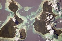
| Aerial view of the Tayando Islands with Tayando in the foreground | ||
The Indonesian Tayando Islands or Tayandu Islands ( Indonesian Kepulauan Tayando ) are located in the southeastern area of the Moluccas in the Banda Sea . They belong to the Kei Islands.
geography
location
The Tayando Islands are located west of the main islands of the Kei Group, beyond the Tayando Strait between 5 ° 31 'and 5 ° 47' south latitude and 132 ° 10 'and 132 ° 22' east longitude . To the west of the Kurstraße there are also Kur and other small islands of the Kei Islands, further away the Aru Islands . North of the archipelago you come to the Vogelkop Peninsula on the island of New Guinea .
The Tayando Islands consist of the three larger islands Tayando (Tayandu) in the northeast, Walir in the center and a little further in the southwest Tam (Taam) . Smaller islands are Heniar (Haniar, Heniaar) , Ree , Reeyanat , Nusreen , Furalnur , Nuwait , Nuniai (Nunyel) and three other small islands near Tam. The total land area of the islands is 69.07 km².
Administrative division
Administratively, the Tayando Islands are a district ( Kecamatan ) Tayando Tam part of the city of Tual ( Kota Tual ), the capital of the Kei Islands on the eastern island of Kei Dullah . This is directly subdivided into that of the Indonesian province of Maluku .
Tayando Tam was separated from Kei Kecil as an independent district in 2004 and after 2013 it was added to the administrative district of the Southeast Moluccas (Maluku Tenggara) of the city of Tual.
The Tayando Tam district is divided into the villages (Desa) Tam Ngurhir (with the islands of Tam, Nusren and Nuniai), Tayando Langgiar (east of Tayando), Tayando Ohoiel (south of Tayando), Tayando Yamru (north-west of Tayando) and Tayando Yamtel (Heniar, Walir, Ree). After 2010, the new Desa Tam Ohoitom (separated from Tam Ngurhir) and Tam Ngurnila emerged . The main town is Tayando Yamtel.
topography
There are no major rivers or lakes on the islands. The Raja , the highest point of the islands with 84 m is located on the island of Tayando.
climate
The climate is characterized by four to five months of rain and a dry season from April to October. The heaviest rainfall occurs between December and February when the wind is blowing from the northwest. In January and February the winds can be very strong. From April to October the wind blows from the east and southeast. The average annual rainfall is 2000-3000 mm. There are an average of 118 rainy days a year. The temperature fluctuates over the course of the year between 24 ° C and 34.1 ° C with an average temperature of 27.1 ° C. The average humidity is 82.5%, the average air pressure 1009.3 hPa.
Residents
The islands of Tayando, Heniar, Walir and Tam are inhabited.
In 2010 the Tayando Tam district had 5,448 inhabitants, in 2012 there were 5,266 (2,567 men and 2,659 women). The population density is 84 people per square kilometer. The people live in 1,097 households, the average household has five people. Tayando Yamtel is the largest village with 2,306 inhabitants.
As on other of the Kei Islands, the Austronesian Kei ( Saumlaki, Veveu Evav ) is spoken on Tayando Islands .
The residents of the Tayando Islands are all Muslim. There are seven mosques and a Muslim chapel. There are no Christian churches.
Facilities
There are eight primary schools on the islands, which are spread across all the villages on the island. There are also three junior high schools and a senior high school in Tayando Yamtel. There is an average of 20 students per elementary school teacher, in junior high school the ratio is 1:12 and in senior high school 1: 9. Class sizes are 17 students in elementary school, 24 in junior high school, and 20 in senior high school. A total of around 1500 children and young people attend the schools.
There is no hospital on the Tayando Islands, but there is a community health center, three sub-centers, nine service stations and two maternity wards.
Some villages have football and volleyball fields.
economy

Most of the inhabitants make a living from agriculture or fishing. 49.19 km² of the islands' land area is cultivated (71% of the total area). The main product is cassava. In 2012, 108 tons were harvested. Cassava is the main food on the islands. Only 1,039 goats, 3,400 chickens and 120 ducks are kept as farm animals. The 384 fishermen work mainly with traditional fishing rods from boats without motors. Of the 298 boats, only 47 have engines, with all but six of them being outboard engines. In 2012 a total of 2,907.6 tonnes of fish were caught. Algae are also harvested.
Only small amounts of coastal sand and limestone are mined on the islands.
Electricity comes from 165 diesel generators on the island; there is no public electricity network. Drinking water mostly comes from local wells.
59 shops are spread across the various villages. Four companies are based on the islands. There are no banks.
There are no restaurants or accommodation for tourists on the islands.
Transport and communication
From the outside world, the main town of Tayando Yamtel can only be reached by sea from the city of Tual, 49.2 kilometers away. From here you can travel to the other villages by boat. On Tayando there are roads between the three villages. The roads are in a very bad condition. The transport on land is done by motorcycle. There is no infrastructure for landline or cell phones.
politics
The term of office of a district chief (Camat) is one year. From 2004 to 2008 A. Ingratubun held the office, then DJS Rahareng took over .
In 2012, nine active political parties were registered in the district: Partai Keadilaan Sejahtera (PKS), Partai Amanat Nasional (PAN), Partai Kebangkitan Bangsa (PKB), Partai Nasional Indonesia (PNI), Golkar (Partai Golongan Karya), Partai Persatuan Pembangunan (PPP) ), Partai Demokrasi Indonesia - Perjuangan (PDI-P), Partai Bintang Reformasi (PBR) and Partai Demokrat .
Web links
- Tyani Fitrian: Seagrass community structure of Tayando-Tam Island, Southeast Moluccas, Indonesia , 2017, doi : 10.13057 / biodiv / d180250
Individual evidence
- ↑ a b c d e f g h i j k l m n o p q r s t u v Regency of Maluku Tenggara: TAYANDO TAM DALAM ANGKA 2013 - TAYANDO TAM IN FIGURES 2013 , ISSN 0215-2444 , accessed on November 8 2017.
- ↑ a b Map of Kota Tual
- ↑ Map of the Eastern Kei Islands
- ↑ a b Penduduk Indonesia menurut desa 2010 ( Memento from March 27, 2014 in the Internet Archive ) (Indonesian; PDF; 6.0 MB), accessed on January 26, 2013.
- ^ Language map of the Moluccas and West Papua
- ↑ Ethnologue: Kei


