Thurntaler
| Thurntaler | ||
|---|---|---|
|
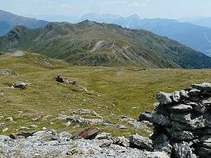
Thurntaler (view from Hochrast) |
||
| height | 2404 m above sea level A. | |
| location | Tyrol , Austria | |
| Mountains | Villgraten mountains | |
| Dominance | 1.7 km → Hochrast | |
| Notch height | 117 m ↓ Astattsattel | |
| Coordinates | 46 ° 46 ′ 0 ″ N , 12 ° 23 ′ 0 ″ E | |
|
|
||
The Thurntaler is 2404 m above sea level. A. high mountain in the Villgraten mountains in East Tyrol . It is a hiking area in summer and a ski area in winter with approx. 45 km of slopes, which are accessed by six lifts (two drag lifts, three chair lifts and a gondola lift with two sections). In winter, the mountain offers two valley runs that run eleven and nine kilometers to Sillian or the Villgratental . The total area of the slopes is around 60 hectares. There are also two rest stops on the Thurntaler: the Gadein panorama restaurant and the Thurntaler Rast .
Since the winter season 2000/2001 there is also a 300 meter long snow park. Below the summit is a reservoir that is used for the snow cannons in winter .
The mountain can be reached by a mountain road all year round.
Even paragliders use throughout the year in good weather the summit as a starting point for their flights into the valley to Sillian.
literature
- Rudolf and Siegrun Weiss: Bergwander-Atlas Osttirol & Südtiroler Dolomiten , Schall-Verlag, Vienna 2006. ISBN 978-3-900533-44-1

