Tiengemeten
| Tiengemeten | ||
|---|---|---|
| Oblique aerial view | ||
| Waters | Haringvliet | |
| Geographical location | 51 ° 44 ′ 0 ″ N , 4 ° 19 ′ 0 ″ E | |
|
|
||
| length | 7.1 km | |
| width | 2 km | |
| surface | 10.22 km² | |
| Highest elevation | 1.6 m | |
| Residents | 10 (2008) <1 inh / km² |
|
| main place | Tiengemeten (district) | |
| Location in the municipality of Korendijk | ||
Tiengemeten is an inhabited Dutch island.
geography
The island lies in the Haringvliet , a common estuary of the Meuse and Waal , between the (now connected to the mainland) island of Goeree-Overflakkee and the mainland south of Rotterdam . The island is about 7 kilometers (km) long, up to 2 km wide and reaches a natural height of max. 1.6 meters above sea level . Tiengemeten has an area of 1022 ha (10.22 km²), of which a good 700 ha were diked. Tiengemeten has two small ports that connect it to the mainland.
administration
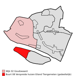
The island is located in the province of South Holland and belongs to the municipality of Hoeksche Waard (until 2018 Korendijk ). The western uninhabited third with a size of 330 hectares belongs to the municipality ( Wijk ) Goudswaard, while the larger eastern part with 692 hectares and the total population of 10 inhabitants (as of 2008) belongs to Zuid-Beijerland.
history
The island emerged from a mudflat that has not been flooded since the 17th century when the water level was normal and was finally diked in between 1750 and 1860. The oldest of the Mariapolder polder is located in the east of the island.
Large parts of the island were used for agriculture until the 1990s; In the 1970s there were also considerations to build a relief city for Rotterdam, an extensive holiday and leisure facility, a cargo airport or a storage facility for contaminated silt.
After the last farmer left the island in May 2007, 11 residents remained.
Planning
In the 1990s, the decision was made to turn the island into a nature park, not least because of the sometimes rare flora and fauna. Most of the residents were moved to relocate by means of compensation payments or adequate new farms, so that Tiengemeten has only 6 permanent residents today (according to Wikipedia) (in contrast to about 60 a good 10 years ago). The dykes were at least partially reopened, so that parts of the island are regularly flooded.
Three new landscape zones are to be created:
- "Wehmut" ( Weemoed ) in the east, a reconstructed polder with historically rebuilt dykes, farmhouses and the cultivation of old grain plants,
- "Abundance" ( Weelde ) in the middle of the island with a predominantly natural flood area without agricultural use and
- "Wilderness" ( wilderness ) in the south and west with nature, which is still almost untouched to this day, which largely consists of inaccessible reed and thatched areas.
Tiengemeten will continue to be a destination for “gentle tourism” in the future. So z. B. a newly created terp can provide an overview of the island.
Photo gallery
Web links
- Tiengemeten Natuurmonumenten (Dutch)


