Korendijk
 flag |
 coat of arms |
| province |
|
| local community |
|
|
Area - land - water |
100.47 km 2 76.15 km 2 24.32 km 2 |
| Residents | 11,247 (Sep 30, 2018) |
| Coordinates | 51 ° 46 ′ N , 4 ° 19 ′ E |
| Important traffic route |
|
| prefix | 0186 |
| Postcodes | 3264-3265, 3267, 3284 |
| Website | Homepage of Korendijk |
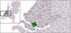
Korendijk ( ) was a municipality in the Netherlands , province of South Holland . On September 30, 2018, it had 11,247 inhabitants on a total area of around 100.5 km². On January 1, 2019, it was merged with the municipalities of Cromstrijen , Binnenmaas , Oud-Beijerland and Strijen to form the new municipality of Hoeksche Waard .
Location and economy
The municipality forms the west of the island of Hoeksche Waard , southwest of Rotterdam . The island of Tiengemeten is also part of Korendijk. It can be reached via the Rotterdam - Bergen op Zoom / Roosendaal motorway; the nearest train station is in Rotterdam, 20-25 km away. A river called Spui, over which there are no bridges and only one ferry that runs several times a day, separates Korendijk from the northern neighbor Spijkenisse . The municipality is bounded in the south by the Haringvliet .
Korendijk is economically dependent on agriculture. But many of the residents commute to work in and around Rotterdam. Korendijk is a center of Orthodox- Calvinist Protestants and part of the Dutch Bible Belt .
history
The village of Goudswaard was established in the middle of the 13th century. After the flood of November 18, 1421, a dike, the Corendijk , was built. The polder was enlarged in 1559 when Lamoral Graf von Egmont acquired the area and had it dyed. The Beijerlande, named after his wife Sabine von Bayern, emerged . The island of Tiengemeten served as a quarantine area for imported goods from the Dutch East Indies from around 1750 to 1850 . The flood disaster of February 1, 1953 led to the Haringvliet being dammed. Tiengemeten was declared a nature reserve ( wetland ) in 1997 and evacuated.
Attractions
- The island of Tiengemeten can be visited under the guidance of employees of the owner, the association "Natural Monuments", by appointment. It should be further developed as a nature area.
- the bird reserve and the reed and rush area Korendijkse Slikken .
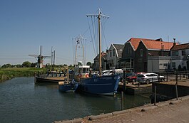
- a bike tour through the community, over narrow dikes, is recommended. You can see beautiful old farms and windmills in a picturesque, typically Dutch landscape.
- all villages have a beautiful village church, mostly from the 17th century.
politics
fusion
The municipalities of Binnenmaas , Cromstrijen , Korendijk, Oud-Beijerland and Strijen were merged into a new municipality with the name Hoeksche Waard on January 1st, 2019 .
Distribution of seats in the municipal council
The local elections on March 19, 2014 resulted in the following distribution of seats:
| Political party | Seats | |||
|---|---|---|---|---|
| 2002 | 2006 | 2010 | 2014 | |
| SGP | 4th | 4th | 4th | 4th |
| Community concerns | 3 | 2 | 2 | 3 |
| CDA | 3 | 3 | 3 | 3 |
| VVD | 3 | 3 | 3 | 2 |
| PvdA | 2 | 3 | 2 | 1 |
| GroenLinks | - | - | 1 | 1 |
| D66 | - | - | - | 1 |
| total | 15th | 15th | 15th | 15th |
Due to the merger on January 1, 2019, the elections for the council of the new Hoeksche Waard municipality took place on November 21, 2018.
mayor
Servaas Stoop ( SGP ) was the acting mayor of the municipality from February 1, 2013 to December 31, 2018 . His colleagues included the alderman Paul Boogaard ( CDA ), Gerard den Boer (SGP) and the acting community secretary Kees Blaak .
Political structure
The community was divided into the following districts:
| No. | place | Residents |
|---|---|---|
| 00 | Nieuw-Beijerland | 3,765 |
| 01 | Piershil | 1,725 |
| 02 | Goudswaard | 1,985 |
| 03 | Zuid-Beijerland | 3,480 |
| local community | 10,959 | |
Web links
- Website of the municipality (Dutch)
- Website about the future of the municipalities in Hoeksche Waard (Dutch)
Individual evidence
- ↑ Bevolkingsontwikkeling; regio per maand . In: StatLine . Centraal Bureau voor de Statistiek , accessed January 1, 2019 (Dutch)
- ↑ Bestuurlijke toekomst Hoeksche Waard Gemeente Korendijk, accessed on June 2, 2018 (Dutch)
- ↑ Result of the local elections: 2010 2014 , accessed on June 2, 2018 (Dutch)
- ↑ Allocation of seats in the municipal council: 2002 2006 2010 2014 , accessed on June 2, 2018 (Dutch)
- ↑ Informatiebijeenkomst gemeenteraadsverkiezingen gemeente Hoeksche Waard Gemeente Korendijk, accessed on June 2, 2018 (Dutch)
- ^ Servaas Stoop burgemeester Korendijk. In: RTV Rijnmond. December 18, 2012, accessed June 2, 2018 (Dutch).
- ↑ Samenstelling college B&W Gemeente Korendijk, accessed on June 2, 2018 (Dutch)
- ↑ Kerncijfers wijken en buurten 2017 Centraal Bureau voor de Statistiek , accessed on June 2, 2018 (Dutch)

