Tigoda
|
Tigoda Ти́года |
||
| Data | ||
| Water code | RU : 01040200612102000019186 | |
| location | Oblasts Leningrad , Novgorod ( Russia ) | |
| River system | Neva | |
| Drain over | Volkhov → Neva → Baltic Sea | |
| source | in Tosnenski rayon 59 ° 3 '58 " N , 31 ° 1' 6" O |
|
| Source height | 55 m | |
| muzzle | 12 km south of Krischi in the Volkhov Coordinates: 59 ° 22 '3 " N , 31 ° 53' 41" E 59 ° 22 '3 " N , 31 ° 53' 41" E |
|
| Mouth height | 17 m | |
| Height difference | 38 m | |
| Bottom slope | 0.27 ‰ | |
| length | 143 km | |
| Catchment area | 2290 km² | |
| Outflow location: 86 km above the mouth |
MQ |
4.3 m³ / s |
| Small towns | Ljuban | |
|
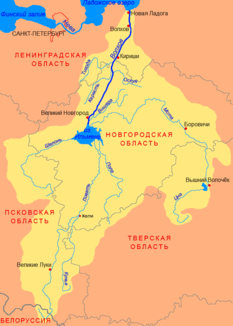
Course of the Tigoda (Ти́года) in the catchment area of the Volkhov |
||
The Tigoda ( Russian Ти́года ) is a left tributary of the Volkhov in the Russian oblasts of Leningrad and Novgorod .
The Tigoda rises in Tosnenski rajon of Leningrad Oblast. It initially flows in a northeastern direction. She passes the small town of Ljuban . In the lower reaches it turns to the south and finally to the northeast again. It eventually runs along the border with Novgorod Oblast. 12 km south of Krischi it reaches the Volkhov, which flows northwards.
The Tigoda has a length of 143 km. It drains an area of 2290 km². It is mainly fed by the snowmelt . In April and May it leads to floods . 86 km above the mouth, the mean discharge is 4.3 m³ / s. The river freezes in November / December. At the end of March / April the river is free of ice again.
At least in the past, rafting was carried out on the Tigoda .

