Todos Santos (Mexico)
| Todos Santos | ||
|---|---|---|
|
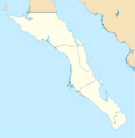
Coordinates: 23 ° 27 ′ N , 110 ° 14 ′ W Todos Santos on the map of Baja California Sur
|
||
| Basic data | ||
| Country | Mexico | |
| State | Baja California Sur | |
| Municipio | La Paz | |
| City foundation | 1734 | |
| Residents | 5148 (2010) | |
| Detailed data | ||
| height | 10 m | |
| Post Code | 23300 | |
| prefix | 612 | |
Todos Santos is located in the Mexican state of Baja California Sur and belongs to the municipality of La Paz . The place has about 5000 inhabitants and is in the list of Pueblos Mágicos .
location
Todos Santos is just 3 kilometers from the Pacific Ocean just above sea level . It's practically right on the Tropic of Capricorn .
The distance to La Paz is 81 kilometers, the distance to Cabo San Lucas 75 kilometers, where the four-lane MEX-19 leads.
Special
- The climate of the place is temperate. Vegetable growing takes place in the area.
- There are many pristine beaches around Todos Santos, which are also suitable for surfing thanks to the high waves.
Web links
Commons : Todos Santos - Collection of images, videos and audio files
