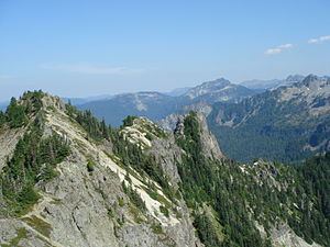
Tolmie Peak
| Tolmie Peak | ||
|---|---|---|
|
View of the ridge from the summit |
||
| height | 1804 m (Sea Level Date of 1929) | |
| location | Pierce County , Washington , USA | |
| Mountains | Cascade chain | |
| Notch height | 232 m | |
| Coordinates | 46 ° 57 '29 " N , 121 ° 52' 38" W | |
|
|
||
The Tolmie Peak is a 5,920 ft (1,804 m) high peak in the area of Mount Rainier in the Cascade Range in the State of Washington . It is located 2 mi (3.2 km) northwest of Mowich Lake in the northwest portion of Mount Rainier National Park .
The streams that flow down from the slopes of Tolmie Peak, such as Tolmie Creek and Ranger Creek, flow into the Carbon River , which drains over the Puyallup River into the Puget Sound . Just south of Tolmie Peak lies Eunice Lake in a basin formed by glaciers . To the northwest is Howard Peak.
Tolmie Peak is named after William Fraser Tolmie . Tolmie, an employee of the Hudson's Bay Company and stationed at the newly built Fort Nisqually , was the first white man to report on the exploration in the Mount Rainier area in August 1833. Impossible for Tolmie and two Native American guides, Lachalet and Nuckalkat, to climb the Rainier themselves, they climbed one of the snow-capped peaks near the headwaters of the Mowich River . Although Tolmie Peak is named after this event, the exact location of their summit storm is unknown.
Individual evidence
- ↑ Tolmie Peak, Washington . peakbagger.com. Retrieved July 11, 2018.
- ↑ Fred W. Beckey : Columbia River to Stevens Pass (= Cascade Alpine Guide), 3rd edition, Volume 1, The Mountaineers Books, 2000, ISBN 0-89886-577-8 .
- ↑ Harry M. Majors: Exploring Washington . Van Winkle Publishing Co, 1975, ISBN 9780918664006 , p. 125.
- ^ Murray Morgan: Puget's Sound: A Narrative of Early Tacoma and the Southern Sound . University of Washington Press, Seattle 1979, ISBN 0-295-95842-1 , pp. 30-36.
Web links
- Tolmie Peak ( English ) In: Geographic Names Information System . United States Geological Survey .
- Tolmie Peak . summitpost.org. Retrieved July 11, 2018.

