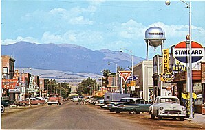
Townsend, Montana
| Townsend | |
|---|---|
| Nickname : First City on the Missouri & Valley of Adventure | |
 Townsend Main Street |
|
| Location in Montana | |
| Basic data | |
| Foundation : | 1883 |
| State : | United States |
| State : | Montana |
| County : | Broadwater County |
| Coordinates : | 46 ° 19 ′ N , 111 ° 31 ′ W |
| Time zone : | Mountain ( UTC − 7 / −6 ) |
| Residents : | 1,878 (as of 2010) |
| Population density : | 459.2 inhabitants per km 2 |
| Area : | 4.12 km 2 (approx. 2 mi 2 ) of which 4.09 km 2 (approx. 2 mi 2 ) is land |
| Height : | 1171 m |
| Postal code : | 59644 |
| Area code : | +1 406 |
| FIPS : | 30-74575 |
| GNIS ID : | 0792298 |
| Website : | www.townsendmt.com |
| Mayor : | Mary Alice Upton |
Townsend is a city in the US state of Montana , United States and the administrative seat of Broadwater County .
geography
Townsend is located in western Montana near the southern tip of Canyon Ferry Lake, a popular recreation area and Montana's third largest body of water. The urban area has a size of 4.12 km², of which 4.09 km² is land and 0.03 km² is water. The town is approximately 35 miles from both Montana's capital, Helena, and the confluence of the Jefferson , Madison and Gallatin Rivers . These three rivers form the headwaters of the Missouri River .
In 2010 the population was 1,878.
history
In 1805, Meriwether Lewis and William Clark crossed what is now Townsend on their Lewis and Clark expedition , but the first white settlers did not settle here until the early 1860s. To support gold mining in the region, Townsend got a train station in 1883. The city is named after the wife of Charles Barstow Wright, who was president of the Northern Pacific Railroad from 1875 to 1879 .
sons and daughters of the town
- Patrick Duffy (born 1949), American actor
Individual evidence
- ↑ Townsend website: City Council (English)
- ↑ United States Census Bureau (English)
Web links
- Official website of Townsend (English)
