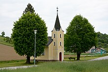
Trdkova
Trdkova ( Hungarian : Turk) is a village and part of the municipality of Kuzma in the Prekmurje region in Slovenia and has about 300 inhabitants.
geography
The settlement is scattered around the headwaters of the Lukaj brook, which drains the north-eastern part of the municipality towards the south. Located along the watershed of the Mur and Raab springs from Zeming-, Seniški- or Turk Bach , who after Hungary flows through to Raab. The highest elevations in the local area are Slamarin breg ( 388 m. In the year ) and the Tromejnik hill ( 390 m. In the year ) with the border triangle between Slovenia, Austria and Hungary. The large mixed forests in the area are rich in mushrooms; In addition to pines, spruces and beeches, the sweet chestnut is also partly represented.
history
The place is mentioned for the first time in 1387 as Trekwlgh , then part of the Dobra manor , today's Neuhaus am Klausenbach in southern Burgenland . In 1388 the name Terkulge appears and the place name Therekwelghye is documented for 1499 . In a protocol of the diocese of Raab / Győr for 1698 the place name Turk is recorded.
In the 19th century the village was united with the neighboring settlement Martiny and in 1890 was given the official place name Magasfóg. At that time the village had 707 inhabitants, 701 of them known as Slovenes, five as Germans and one as Hungarian, it belonged to the Szentgotthárd district of Eisenburg / Vas county .
The Trianon Treaty gave the village to the Kingdom of SHS . For the place now officially named Trdkova, the census on January 31, 1921 found the following data: 735 Slovenes, all residents professed to be Catholic.
The 1931 census found 591 inhabitants; in 1961 there were 448 and the following figures are known for 1971: 392 inhabitants, 93 houses, 94 households and 364 villagers who live on agricultural income.
Attractions
About an hour's walk from Trdkova is the three-country border between Austria, Slovenia and Hungary. On May 31, 1924, on a hill of 390 m above sea level. a large pyramid-shaped boundary stone was erected by the international border drawing commission. The three individual sides of the pyramid show the coat of arms of the respective state, the year the border was drawn, September 10, 1919, and the date of ratification of the Trianon Treaty, June 4, 1920.
After the Second World War , the monument was no longer accessible due to the “ Iron Curtain ” being drawn. Since June 1989, the border monument has been freely accessible again from each of the neighboring countries. In 1993 the Yugoslav coat of arms was removed and the emblem of the Republic of Slovenia was added.
literature
- Ivan Zelko , Historična Topografija Slovenije I. Prekmurje do leta 1500. Murska Sobota, 1982.
- Matija Slavič, Naše Prekmurje. Murska Sobota, 1999.
- Atlas Slovenije, Ljubljana, 1985.
Web links
Coordinates: 46 ° 51 ′ 13.2 " N , 16 ° 6 ′ 47.4" E


