
Trnava (Međimurje)
| Trnava | ||
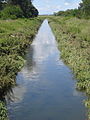
 The Trnava bridge at the main train station in Čakovec |
||
| Data | ||
| location | Croatia | |
| River system | Danube | |
| Drain over | Mur → Drava → Danube → Black Sea | |
| source | near Vukanovec , Gornji Mihaljevec municipality , Međimurje County , Croatia |
|
| Source height | 300 m. i. J. | |
| muzzle | near Goričan , Croatia , in the Mur Coordinates: 46 ° 23 ′ 30 " N , 16 ° 43 ′ 0" E |
|
| Mouth height | 140 m. i. J. | |
| Height difference | 160 m | |
| Bottom slope | 3.4 ‰ | |
| length | 47 km | |
| Catchment area | 250 km² | |
| Left tributaries | Streams Dragoslavec, Goričica, Pleškovec, Knezovec, Hrebec, Brezje, Boščak, Murščak, Korenatica | |
| Right tributaries | Brooks Kopenec and Sratka | |
| Small towns | Čakovec | |
| Communities | Gornji Mihaljevec , Nedelišće , Pribislavec , Mala Subotica , Domašinec , Donji Kraljevec , Goričan | |
The Trnava (full name Trnava Murska ) is an approximately 46.9 km long river in the Međimurje County in northern Croatia . It is a right and western tributary of the Mur , the last major tributary before it flows into the Drava .
The source of the Trnava is located not far from the village of Vukanovec in the Gornji Mihaljevec municipality in the hilly north-western part of the county. After a few kilometers, it continues to flow in an easterly direction through the western edge of the Pannonian Plain , crosses a couple of municipalities or villages ( Macinec , Nedelišće , Pribislavec , Štefanec, Mala Subotica , Palovec , Držimurec , Domašinec , Donji Kraljevec , Turčišće ) and the City of Čakovec and finally flows into the Mur at Goričan at an altitude of 140 m .
On its course it takes in many streams (mostly left tributaries), including Dragoslavec, Goričica, Pleškovec, Knezovec, Hrebec, Brezje, Boščak, Murščak, Korenatica, Kopenec and Sratka. Some of them, as well as the Trnava itself, are partially regulated or canalized , and thus, together with several flood retention basins , flood protection is achieved.
The Trnava catchment area covers about 250 km², which is about 34% of the total area of the county. The river is not navigable.
photos
Trnava near Mala Subotica

The bridge over the Trnava near Držimurec

The lower course of the Trnava river near Goričan

The bridge near the Goričan border crossing


.jpg)
