Trollheimen
Coordinates: 62 ° 51 ' N , 9 ° 5' E
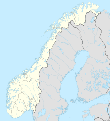
Trollheimen describes a mountain landscape in central Norway between Nordmøre in the north of Fylke Møre og Romsdal and Fylke Trøndelag . The area is also known as "the land of the trolls " and is bordered in the north by Ora- dal and Rindal , Orkdal and Dovre Railway in the east, Sunndal in the south and the fjords in the west.
history
Trollheimen was probably the first area in Norway to become ice-free after the last ice age. There is human evidence that is up to 9000 years old that shows that people began to settle here early. The basis of food was mostly reindeer and elk . Today the area is mainly known for skiing and mountain sports.
The name was proposed by journalist and politician Håkon Løken in the 1880s and has caught on.
Attractions
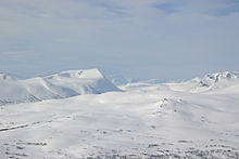
Trollheimen consists of a mountain range with peaks over 1600 m. It is well developed with accommodations and networks of trails. The ski and mountaineering paradise is criss-crossed by two large valleys, the Ora dal and the Sunndal, further south. Between these two valleys is the small Todal fjord . On the northeast bank you can enjoy a great variety of plants. The Orkla River , which is one of the best salmon rivers in Norway , also flows in Trollheimen .
economy
The economic factors in this region include:


