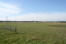
Griesheim military training area
The Griesheim military training area was a military area near Griesheim. Until 1937 the area was in the district of the city of Griesheim and then passed to the city of Darmstadt . Today the area includes the nature reserve "Former August-Euler-Flugplatz ", parts of the nature reserve " Griesheimer Düne und Eichwäldchen " (Griesheimer Sand) and the area "Beckertanne".
history
The first artillery firing exercises in the Griesheimer Sand by Hessian regiments are documented for the year 1864. The units were placed under the Prussian Army in 1866. In 1867, shooting exercises based on the Prussian model followed.
On January 2, 1874, the community of Griesheim sold around 380 hectares of the sand dune area to the Prussian Ministry of War for use as a firing range for the 11th artillery brigade. An average of 20,000 soldiers trained in the Griesheimer Sand every year. On September 24, 1877, Kaiser Wilhelm I visited a maneuver in Griesheim. Staff and officers' buildings were built in the north of the square, some of which are still preserved today, and spacious corrugated iron barracks as crew quarters, which is why the camp was popularly called Wellblechhausen. The military training area at the gates of Darmstadt, the then capital of the Grand Duchy of Hesse , was accessible from 1886, among other things, with the Darmstadt steam tram and a siding for a supply railway.
After August Euler had founded the oldest German flying machine factory in October 1908, he leased the foot parade ground of the training ground for his flight attempts and opened Germany's first airfield, the current August Euler airfield .
During the First World War, the site also served as a prisoner-of-war camp for 15,000 soldiers. Between 1914 and 1918, 605 prisoners of war died in the camp and were buried in the Darmstadt forest cemetery.
In December 1918, the French army occupied the training area and the airport. The practice area was used by French units until 1930. From October 1, 1937, on the instructions of the Hessian governor Jakob Sprenger, the entire practice area, today's Tann settlement, the forest areas east of the autobahn and in the south as far as almost Eschollbrücker Chaussee, a total of 800 ha, to Darmstadt.
After the Second World War , 210 hectares of the military training area were used by the United States Army together with the airfield , largely as a training area for the units stationed in Darmstadt. The airfield was the base of a rescue helicopter squadron and was used by the US Army until 1992.
Nature reserve
Parts of the former military training area, a large part of the August Euler airfield , the neighboring area "Beckertanne" (from old German Beck , " Bach " and " Tanne "), which is used as a training area by the United States Army ( US Army ) as Darmstadt was also used by the Bundeswehr , as well as the adjacent nature reserve " Griesheimer Düne und Eichwäldchen", have been a fauna-flora habitat recognized by the European Union since around 2000 . Some areas have been renatured .
The area is also designated as a bird sanctuary " Griesheimer Sand ".
Commanders of the military training area
- Viktor von Randow (1913–1914)
literature
- Ursula Eckstein: August Euler Airfield Darmstadt. Justus von Liebig Verlag Darmstadt 2008, ISBN 978-3-87390-255-8 .
- Monument topography Federal Republic of Germany , cultural monuments in Hesse: City of Darmstadt . Vieweg, Braunschweig 1994, ISBN 3-528-06249-5 .
Web links
Individual evidence
- ^ Map of the 1910 military training area, 1: 25000. (No longer available online.) Ernst Moritz Arndt University of Greifswald, Faculty of Mathematics and Natural Sciences, Institute for Geography and Geology, 2013, archived from the original on May 12, 2013 ; Retrieved July 14, 2013 . Info: The archive link was inserted automatically and has not yet been checked. Please check the original and archive link according to the instructions and then remove this notice.
- ^ Map of the military training area 1936, 1: 25000. (No longer available online.) Ernst Moritz Arndt University of Greifswald, Faculty of Mathematics and Natural Sciences, Institute for Geography and Geology, 2013, archived from the original on May 12, 2013 ; Retrieved July 14, 2013 . Info: The archive link was inserted automatically and has not yet been checked. Please check the original and archive link according to the instructions and then remove this notice.
- ↑ Ursula Eckstein: August-Euler-Flugplatz Darmstadt , p. 15
- ↑ Wind tunnel of the TU Darmstadt: Historical overview.Retrieved on August 11, 2013
- ^ Cultural monuments in Hesse. City of Darmstadt. ed. by the State Office for the Preservation of Monuments in Hesse in cooperation with the City Administration of Darmstadt, Braunschweig / Wiesbaden 1994, ISBN 3-528-06249-5 , p. 538
- ↑ Germany's oldest airfield turns 100 - anniversary event with a large air show. Press release from TU Darmstadt on August 14, 2008
- ↑ http://www.walter-kuhl.de/riedbahn/ersterwk.htm
- ↑ Bundesarchiv ( page no longer available , search in web archives ) Info: The link was automatically marked as defective. Please check the link according to the instructions and then remove this notice.
- ^ W. Dragoons: The Bundeswehr 1989 Organization and equipment of the armed forces of the Federal Republic of Germany at the end of the Cold War . Supplement location directory, 2nd edition February 2012, p. 309 ( Memento from July 27, 2013 in the Internet Archive )
- ↑ Standard data sheet excerpt for VR area: 6117-401 "Griesheimer Sand" ( page no longer available , search in web archives ) Info: The link was automatically marked as defective. Please check the link according to the instructions and then remove this notice.
- ↑ Map (PDF; 450 kB) of the bird sanctuary "Griesheimer Sand"
Coordinates: 49 ° 50 ′ 56 " N , 8 ° 35 ′ 3.3" E

