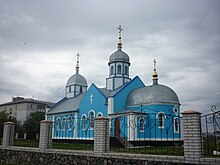
Chervona Sloboda (Cherkassy)
| Tscherwona Sloboda | ||
| Червона Слобода | ||

|
|
|
| Basic data | ||
|---|---|---|
| Oblast : | Cherkasy Oblast | |
| Rajon : | Cherkasy Raion | |
| Height : | 88 m | |
| Area : | 14.78 km² | |
| Residents : | 9,501 (2004) | |
| Population density : | 643 inhabitants per km² | |
| Postcodes : | 19604 | |
| Area code : | +380 472 | |
| Geographic location : | 49 ° 23 ' N , 32 ° 9' E | |
| KOATUU : | 7124989001 | |
| Administrative structure : | 1 village | |
| Address: | вул. Чапаєва 2/1 19604 с. Червона Слобода |
|
| Statistical information | ||
|
|
||
Chervona Sloboda ( Ukrainian Червона Слобода ; Russian Червоная Слобода Chervonaja Sloboda ) is a village in the central Ukrainian Cherkassy Oblast with about 9500 inhabitants (2004).
The village, first mentioned in 1648, was called Zarska Sloboda ( Царська Слобода ) until 1923 and forms its own district council within the Cherkassy Rajon .
It is bordered to the northwest and west to the urban area of the Oblasthauptstadt Cherkassy and in the northeast to the south bank of the kremenchuk reservoir dammed Dnepr . The regional road P – 10 runs through Tscherwona Sloboda .
Web links
Commons : Tscherwona Sloboda - Collection of images, videos and audio files
Individual evidence
- ^ Website of the village on the Verkhovna Rada website , accessed on April 26, 2015


