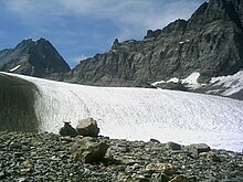
Tschingelfirn

The Tschingelfirn is a valley glacier on the northern slope of the Bernese Alps , in the canton of Bern of Switzerland . It has a length of 3.5 km, is up to 2 km wide and covers an area of almost 6 km².
The Tschingelfirn takes its starting point on the northwest flank of the Tschingelhorn at over 3300 m . First, the glacier flows steeply northwards down the slope. Another arm joins the valley from the eastern flank of the Blüemlisalp . The Tschingelfirn then moves east, being flanked in the north by the striking rocky ridge of the Gspaltenhorn and the Tschingelspitz . The glacier tongue is currently at an altitude of around 2200 m. It drains into the Tschingel-Lütschine, which later joins another spring stream to form the Weisse Lütschine and flows through the Lauterbrunnen valley to Lake Brienz .
To the west, the Tschingelfirn has a connection with the Kanderfirn north and south of the Mutthorn via firn-covered passes ( Tschingelpass ) . The Mutthornhütte of the Swiss Alpine Club SAC stands on a promontory of the Mutthorn at 2900 m and can only be reached via glaciers, either from the Gastern Valley or the Lauterbrunnen Valley.
During the high stage of the Little Ice Age around the middle of the 19th century, the glacier tongue of the Tschingelfirn (also Tschingel glacier) was connected to that of the Breithorn glacier. Due to the melting of the glaciers, this western part of the Breithorn Glacier is almost completely cut off today and is called the Wetterlücke Glacier. This glacier extends over a length of 2 km on the eastern flank of the Tschingelhorn.
literature
- Charles Knapp, Maurice Borel, Victor Attinger, Heinrich Brunner, Société neuchâteloise de géographie (editors): Geographical Lexicon of Switzerland . Volume 6: Tavetsch Val - Zybachsplatte, supplement - last additions - appendix . Verlag Gebrüder Attinger, Neuenburg 1910, p. 203, keyword Tschingelfirn ( scan of the lexicon page ).
Web links
- Tschingelfirn, Lauterbrunnen (BE) in the Swiss glacier measuring network of the Research Institute for Hydraulic Engineering, Hydrology and Glaciology at the ETH Zurich
Individual evidence
Coordinates: 46 ° 30 '0 " N , 7 ° 50' 33" E ; CH1903: six hundred and thirty-one thousand and two / 149,934

