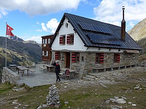
Turtmannhütte
| Turtmannhütte SAC hut |
||
|---|---|---|
| location | Turtmann Valley ; Valais ; Valley location: Gruben VS | |
| Mountain range | Valais Alps , Weisshorn Group | |
| Geographical location: | 620151 / 112100 | |
| Altitude | 2519 m above sea level M. | |
|
|
||
| owner | SAC - Prevôtoise section | |
| Built | 1928 | |
| Construction type | hut | |
| Development | various hiking trails starting from pits, 2–3 h | |
| Usual opening times | June to mid-September | |
| accommodation | 0 beds, 50 camps | |
| Web link | Turtmannhütte | |
| Hut directory | SAC | |
The Turtmannhütte of the Swiss Alpine Club (SAC) is located in the Turtmann Valley above Gruben at 2519 m above sea level. M. It is the starting point for full speed Brunegghorn ( 3833 m ), the Bishorn ( 4153 m ), Les Diablons ( 3609 m ), Schöllihorn ( 3500 m ) and the highest hiking peak in Switzerland, the Barrhorn ( 3610 m ).
Before the construction of the cable car from Turtmann to Oberems and the road from Oberems to Gruben in 1958, the Turtmannhütte, which opened in 1928 with 30 seats, was the most remote of all SAC huts. To reach it, Turtmann had to overcome a distance of around 18 km and an altitude difference of 1900 m. The time required for this was around nine and a half hours.
swell
- Turtmannhütte website , accessed on November 24, 2012
- Website of the Valais Huts , accessed on November 24, 2012
- Alois Grichting: Turtmann Valley. In: Historical Lexicon of Switzerland .
Individual evidence
- ↑ SAC Club hut album 1928/1931 , 1937/1946 supplemented, graphic arts institution Brunner & Cie. A.-G., Zurich
Panorama from the Turtmannhütte
Web links
Commons : Turtmannhütte - Collection of images, videos and audio files


