Uhabia
|
Uhabia Ouhabia |
||
| Data | ||
| Water code | FR : S50-0400 | |
| location | France , Nouvelle-Aquitaine region | |
| source | in the municipality of Saint-Pée-sur-Nivelle, 43 ° 22 ′ 31 ″ N , 1 ° 30 ′ 43 ″ W |
|
| Source height | approx. 130 m | |
| muzzle | in the urban area of Bidart Coordinates: 43 ° 25 '55 " N , 1 ° 35' 51" W 43 ° 25 '55 " N , 1 ° 35' 51" W |
|
| Mouth height | approx. 0 m | |
| Height difference | approx. 130 m | |
| Bottom slope | approx. 8.7 ‰ | |
| length | 15 km | |
|
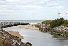
Uhabia in Bidart |
||
The Uhabia (also called Ouhabia ) is a small coastal river in the French Basque Country, which runs in the Pyrénées-Atlantiques department in the Nouvelle-Aquitaine region .
The word "Uhabia" originally comes from the Basque words "ur habia", which translates as "waterhole, watercourse".
course
The Uhabia rises in the municipal area of Saint-Pée-sur-Nivelle under the name Aphalagako Erreka , generally drains in a north-westerly direction and flows into the Bay of Biscay after 15.4 kilometers in the urban area of Bidart . The Alhorgako Erreka and drains from Belhard in the north of Ahetze also flow into it .
Places on the river
The Uhabia flows through u. a. the cities of Ustaritz , Arbonne , Bidart and Saint-Pée-sur-Nivelle in the Pyrénées-Atlantiques department .
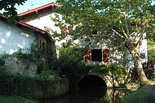
In Bidart it flows through u. a. the historic mill "Moulin de Bassilour", which was built in 1741.
La Plage de l'Uhabia
In Bidart , next to the river, there is also a beach called "La Plage de l'Uhabia", which is located right next to the mouth of the river in the Bay of Biscay and along the D810 road.
Web links
Individual evidence
- ↑ Les plages de Bidart. In: Office de Tourisme de Bidart. October 26, 2015, accessed June 15, 2016 .


