
Urach waterfall

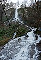
The Urach waterfall is located two kilometers southwest of Bad Urach in the Maisental, a side valley of the Erms . Here the runoff of the source of the Brühlbach, which rises on the edge of the Swabian Alb, falls freely 37 meters into the depth, hits a tuff limestone step and flows another 50 meters over a steeply sloping moss-covered tuff limestone cushion. Depending on the amount of water, several arms of water are formed, which then flow together and continue as the Brühlbach.
Origin and amount of the water
The source rises at a height of 623 m above sea level. NN , about four kilometers northeast of Würtingen . In the vicinity of Würtingen, rainwater seeps through the calcareous rock layers. The carbonated water absorbs lime and collects on the water-impermeable layer of marl below . As a karst spring , it emerges about 28 hours after its seepage on a high meadow below the Albtraufs and forms the waterfall a few meters further on .
The water discharge from the spring varies, depending on the weather and the season, from around 70 l / s, for example in midsummer, up to 420 l / s after heavy rainfall or when the snow melts.
Limescale deposits

When the source emerges, the lime is deposited again . A jagged tufa plateau surrounds the source. The channel of the creek shortly before the crash site of the waterfall was not created by erosion , but by sedimentation , every time the creek spills over, lime is deposited on the edge. Lime precipitated in the middle of the flowing water, on the other hand, is carried away by the current and forms the tuff limestone steps below the waterfall.
The spray produced when the water hits the limestone steps, fine calcareous water droplets are also distributed on leaves, moss, tree trunks, stones and other things in the vicinity of the waterfall and cover them with a layer of lime.
At the crash site of the waterfall, the lime deposited there forms a tuff limestone protrusion that protrudes over the edge of the plateau and continues to grow. Due to its own weight, this limestone nose breaks off from time to time and plunges into the depths.
Geotope worth protecting
Tufa waterfalls are very sensitive geotopes and provide a habitat for some rare animals and plants. Tufa limestone sources can be endangered by various factors, for example mechanical destruction of the fragile tufa formations when animals and people are treadled. This is one of the reasons why the area around the Urach waterfall is triple protected. It is located in the FFH area Uracher Talspinne , belongs to the maintenance zone of the Swabian Alb biosphere area and is part of the Rutschen nature reserve .

Current condition

Originally, the water flowed into the valley in several cases. When it was merged into today's individual waterfall, its appearance changed fundamentally.
The use of the limestone terrace of the Urach waterfall as a quarry for the extraction of building material was discontinued. The tufa was used, among other things, for the construction of the Urach Amandus Church.
On the right side of the waterfall, a path has been created that leads up to the plateau. A tea house operated by the waterfall in the 19th century no longer exists.
2.1 km away (on foot, about twice as far on the road) has been the Bad Urach waterfall stop on the Ermstalbahn since 1873 .
Others
In his poems and in letters to his friends, Eduard Mörike also mentions the waterfall, for example in the poem Visit to Urach . He wrote these verses to his friend Johannes Mährlen about the Urach waterfall:
A waterfall, my friend
We both know well.
How sometimes we stood in front of it,
intoxicating eyes and ears at him
Since we were other boys ...
Different views of the Urach waterfall

The waterfall falls over the limestone nose

Spray mist in the sunlight

The waterfall at the time of the snowmelt
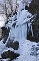
The icy waterfall in January 2017
After heavy rain in January 2018


See also
Web links
- Karst spring
- Channel formation, further links
- Description, pictures
- Eduard Mörike, "Visit to Urach"
- Map with Urach waterfall and surroundings on: State Agency for the Environment Baden-Württemberg (LUBW) ( information )
- Map with Urach waterfall and hiking trails on: Geoportal Baden-Württemberg ( information )
Coordinates: 48 ° 28 ′ 56 " N , 9 ° 22 ′ 4" E