Brühlbach (Erms, Bad Urach)
| Bruehlbach | ||
|
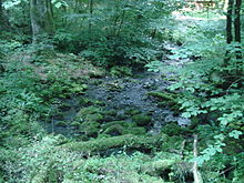
The Brühlbach between the waterfall and Bad Urach |
||
| Data | ||
| Water code | DE : 23817652 | |
| location |
Swabian Alb
|
|
| River system | Rhine | |
| Drain over | Erms → Neckar → Rhine → North Sea | |
| source | southwest of the Urach waterfall 48 ° 28 ′ 53 ″ N , 9 ° 21 ′ 58 ″ E |
|
| Source height | approx. 615 m above sea level NHN | |
| Spring discharge |
MNQ MHQ |
70 l / s 420 l / s |
| muzzle | At the Bad Urach gauge from the left and south in the Erms coordinates: 48 ° 30 ′ 22 ″ N , 9 ° 22 ′ 29 ″ E 48 ° 30 ′ 22 ″ N , 9 ° 22 ′ 29 ″ E |
|
| Mouth height | approx. 427 m above sea level NHN | |
| Height difference | approx. 188 m | |
| Bottom slope | approx. 55 ‰ | |
| length | 3.4 km | |
| Catchment area | 8.113 km² only superficially | |
|
after the snow melts |
||
The Brühlbach is a left tributary of the Erms near Bad Urach in Baden-Württemberg , which feeds the Urach waterfall .
geography
Brühlbach springs
The sources of the Brühlbach are located about 150 m southwest of the Urach waterfall. There are several karst springs that emerge in a rugged tufa plateau. The water comes from the plateau around Würtingen . Rainwater seeps through the calcareous rock layers there. The carbonated water absorbs lime and collects on the water-impermeable layer of marl below . About 28 hours after it seeps away, the water in the Brühlbach springs reappears. The discharge varies depending on the weather and the season from around 70 l / s to 420 l / s. The springs can even run dry in hot summers .
course
After its source, the Brühlbach falls down the Urach waterfall. Below it is reinforced by other sources. It flows through the Brühl in a predominantly northerly direction and - after taking up the Gütersteinbach from the Gütersteiner waterfall - the Maisental . The Brühlbach flows into the Erms near the Bad Urach gauge on the north-western edge of the city .
Catchment area
The superficial catchment area of the Brühlbach covers around 8.1 km², the more relevant in the Karst of the Swabian Alb around 20 km² on lower levels. In the south and southwest, the terrain on the Alb plateau drains over the Gächinger Lauter and the Große Lauter to the Danube . In the northwest competes beyond a short section of the watershed of the downward Erms inflow Glems Bach , to the east of the upward Seltmann Bach otherwise for, Neckar current Erms yourself in. The area adjoins the European watershed at.
Tributaries
List of tributaries from the source to the mouth. Length of water, catchment area and altitude according to the corresponding layers on the LUBW online map. Other sources for the information are noted.
Sources of the Brühlbach at about 615 m above sea level. NHN .
- Falls down the Urach waterfall .
- Inflow, from the right near the southern tip of the open Brühl at 511.1 m above sea level. NHN , approx. 0.1 km. Source at about 530 m above sea level. NHN .
- Bach from the Schiessal , from the left to 475.7 m above sea level. NHN , 1.0 km. Source at about 545 m above sea level. NHN .
- Gütersteinbach , from the left to 443.6 m above sea level. NHN , 2.1 km. Source at about 640 m above sea level. NHN . This tributary falls down the Güterstein waterfall .
Mouth of the Brühlbach , from the left at the Bad Urach thermal baths from the left and south and at about 427 m above sea level. NHN in the Erms . The stream here is 3.4 km long and has an above-ground catchment area (determined on the basis of the separating mountain ridges) of 8.1 km². The catchment area in the lower karst floors is noticeably larger.
Individual evidence
LUBW
Official online waterway map with a suitable section and the layers used here: Course and catchment area of the Brühlbach
General introduction without default settings and layers: State Institute for the Environment Baden-Württemberg (LUBW) ( notes )
- ↑ a b c Height according to the contour line image on the background layer topographic map .
- ↑ a b Length according to the waterway network layer ( AWGN ) .
- ↑ a b Catchment area according to the basic catchment area layer (AWGN) .
- ↑ a b c Height according to the blue lettering on the background layer of the topographic map .
- ↑ Length measured on the background layer topographic map .
Other evidence
- ↑ Hansjörg Dongus : Geographical land survey: The natural spatial units on sheet 171 Göppingen. Federal Institute for Regional Studies, Bad Godesberg 1961. → Online map (PDF; 4.3 MB)
- ^ Hans Graul : Geographical land survey: The natural space units on sheet 179 Ulm. Federal Institute for Regional Studies, Bad Godesberg 1952. → Online map (PDF; 4.8 MB)
literature
- Topographical map 1: 25,000 Baden-Württemberg, as single sheet No. 7422 Lenningen, No. 7521 Reutlingen and No. 7522 Bad Urach


