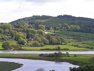
Urr Water
| Urr Water | ||
|
Meander of the Urr Water |
||
| Data | ||
| location | Dumfries and Galloway , Scotland | |
| River system | Urr Water | |
| Drain over | Solway Firth → Irish Sea | |
| source | Discharge from Loch Urr 55 ° 8 ′ 16 ″ N , 3 ° 57 ′ 12 ″ W. |
|
| Source height | around 207 m ASL | |
| muzzle | At Kippford in the Solway Firth coordinates: 54 ° 52 ′ 21 " N , 3 ° 48 ′ 54" W 54 ° 52 ′ 21 " N , 3 ° 48 ′ 54" W.
|
|
| length | 44 km | |
The Urr Water , also Water of Urr , is a river in the Scottish Council Area Dumfries and Galloway , or the traditional county of Kirkcudbrightshire .
course
The river flows off at an altitude of 207 m on the southwest bank of Loch Urr . Its course initially follows a southerly direction. Between the Old Bridge of Urr and the Haugh of Urr it flows for a distance of around four kilometers to the southeast, and then flows again primarily to the south until it reaches a confluence. At Kippford the Urr Water widens and after a total of 44 km it pours into the Solway Firth , which finally merges into the Irish Sea . The up to 1.8 km wide estuary of the Urr Water is known as the Urr Waterfoot .
On its course, numerous streams flow into the Urr Water, but it has no significant tributaries. It runs through a sparsely populated region, so that it affects few localities. The largest town on Urr Water is Dalbeattie . With the Haugh Bridge at Haugh of Urr and the Buittle Bridge near Dalbeattie, two listed bridges cross Urr Water.
Web links
Individual evidence
- ↑ a b c Urr Water in: FH Groome: Ordnance Gazetteer of Scotland: A Survey of Scottish Topography, Statistical, Biographical and Historical. , Grange Publishing, Edinburgh, 1885.
- ↑ a b Entry in the Gazetteer for Scotland
- ↑ Listed Building - Entry . In: Historic Scotland .
- ↑ Listed Building - Entry . In: Historic Scotland .


