Haugh of Urr
| Haugh of Urr | ||
|---|---|---|
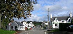
| Main street from Haugh of Urr | ||
| Coordinates | 54 ° 59 ′ N , 3 ° 52 ′ W | |
|
|
||
| administration | ||
| Post town | CASTLE DOUGLAS | |
| ZIP code section | DG7 | |
| prefix | 01556 | |
| Part of the country | Scotland | |
| Council area | Dumfries and Galloway | |
| British Parliament | Dumfries and Galloway | |
| Scottish Parliament | Galloway and West Dumfries | |
Haugh of Urr is a village in the Scottish Council Area Dumfries and Galloway or the traditional county of Kirkcudbrightshire . It is located about five kilometers northwest of Dalbeattie and northeast of Castle Douglas near the left bank of the eponymous Urr Water .
history
Since the 12th century, the Motte von Urr has been a fortification near the village. Haugh of Urr was on one of the Scottish military roads. Today's Urr Parish Church , located on the southern edge, was built in 1914 to a design by the architect P. MacGregor Chalmers .
In the course of the 1971 census survey, 228 people were counted in Haugh of Urr. That was eight residents more than ten years earlier.
traffic
In Haugh of Urr, the B794 coming from Dalbeattie crosses the old military road. The B794 connects the village to the two kilometers north of the A75 trunk road ( Stranraer - Gretna Green ). The A710 and A711 are reached in Dalbeattie . On the western edge of Haugh of Urr was in 1763 with the arch bridge Haugh Bridge , a crossing of the Urr Water built.
Individual evidence
- ^ Entry in the Gazetteer for Scotland
- ↑ Entry on Motte von Urr in Canmore, the database of Historic Environment Scotland (English)
- ↑ a b Listed Building - Entry . In: Historic Scotland .
- ↑ Listed Building - Entry . In: Historic Scotland .
- ^ Information in the Gazetteer for Scotland

